|
|
|||||||||||||||||
| Point ID: 6987 | Downloads | Plots | Site Data | Code: 11199 |
|
|
|||||||||||||||||
| Download | |
|---|---|
| Site Descriptor Information | Site Time Series Data |
| Link to all available data | |
| View: | Time Series | All |
| Units: | mm |
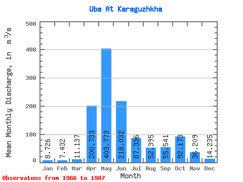
| Statistic | Jan | Feb | Mar | Apr | May | Jun | Jul | Aug | Sep | Oct | Nov | Dec | Annual |
|---|---|---|---|---|---|---|---|---|---|---|---|---|---|
| Mean | 8.73 | 7.43 | 11.14 | 200.73 | 403.77 | 218.03 | 87.34 | 52.40 | 55.54 | 92.17 | 36.21 | 14.23 | 97.87 |
| Standard Deviation | 2.73 | 2.20 | 6.95 | 64.00 | 126.27 | 108.42 | 41.18 | 29.93 | 37.36 | 53.80 | 13.37 | 6.07 | 21.59 |
| Min | 4.97 | 4.60 | 6.11 | 98.40 | 194.00 | 69.20 | 24.30 | 16.60 | 18.60 | 20.40 | 15.20 | 4.11 | 63.82 |
| Max | 17.30 | 14.10 | 39.60 | 379.00 | 725.00 | 473.00 | 189.00 | 109.00 | 176.00 | 218.00 | 64.20 | 28.70 | 145.21 |
| Coefficient of Variation | 0.31 | 0.30 | 0.62 | 0.32 | 0.31 | 0.50 | 0.47 | 0.57 | 0.67 | 0.58 | 0.37 | 0.43 | 0.22 |
 Return to R-Arctic Net Home Page