|
|
|||||||||||||||||
| Point ID: 6758 | Downloads | Plots | Site Data | Code: 10233 |
|
|
|||||||||||||||||
| Download | |
|---|---|
| Site Descriptor Information | Site Time Series Data |
| Link to all available data | |
| View: | Time Series | All |
| Units: | m3/s |
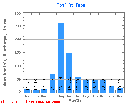
| Statistic | Jan | Feb | Mar | Apr | May | Jun | Jul | Aug | Sep | Oct | Nov | Dec | Annual |
|---|---|---|---|---|---|---|---|---|---|---|---|---|---|
| Mean | 14.86 | 12.23 | 12.97 | 71.80 | 261.40 | 147.28 | 57.28 | 53.75 | 46.67 | 53.00 | 27.60 | 18.52 | 773.49 |
| Standard Deviation | 6.75 | 5.41 | 5.61 | 44.17 | 74.36 | 87.87 | 26.81 | 25.27 | 22.27 | 25.48 | 10.40 | 7.75 | 186.50 |
| Min | 3.46 | 2.24 | 5.99 | 14.66 | 90.50 | 34.68 | 23.58 | 21.67 | 20.38 | 21.36 | 12.16 | 9.42 | 309.92 |
| Max | 30.47 | 25.97 | 29.12 | 244.30 | 403.24 | 408.76 | 134.21 | 120.05 | 100.11 | 117.59 | 56.79 | 42.17 | 1090.27 |
| Coefficient of Variation | 0.45 | 0.44 | 0.43 | 0.61 | 0.28 | 0.60 | 0.47 | 0.47 | 0.48 | 0.48 | 0.38 | 0.42 | 0.24 |
 Return to R-Arctic Net Home Page