|
|
|||||||||||||||||
| Point ID: 6758 | Downloads | Plots | Site Data | Code: 10233 |
|
|
|||||||||||||||||
| Download | |
|---|---|
| Site Descriptor Information | Site Time Series Data |
| Link to all available data | |
|
|
| View: | Statistics | Time Series |
| Units: | m3/s |
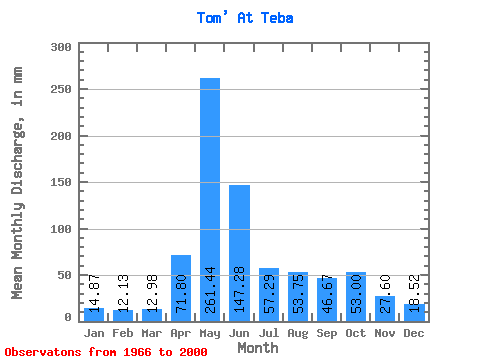
| Statistic | Jan | Feb | Mar | Apr | May | Jun | Jul | Aug | Sep | Oct | Nov | Dec | Annual |
|---|---|---|---|---|---|---|---|---|---|---|---|---|---|
| Mean | 14.86 | 12.23 | 12.97 | 71.80 | 261.40 | 147.28 | 57.28 | 53.75 | 46.67 | 53.00 | 27.60 | 18.52 | 773.49 |
| Standard Deviation | 6.75 | 5.41 | 5.61 | 44.17 | 74.36 | 87.87 | 26.81 | 25.27 | 22.27 | 25.48 | 10.40 | 7.75 | 186.50 |
| Min | 3.46 | 2.24 | 5.99 | 14.66 | 90.50 | 34.68 | 23.58 | 21.67 | 20.38 | 21.36 | 12.16 | 9.42 | 309.92 |
| Max | 30.47 | 25.97 | 29.12 | 244.30 | 403.24 | 408.76 | 134.21 | 120.05 | 100.11 | 117.59 | 56.79 | 42.17 | 1090.27 |
| Coefficient of Variation | 0.45 | 0.44 | 0.43 | 0.61 | 0.28 | 0.60 | 0.47 | 0.47 | 0.48 | 0.48 | 0.38 | 0.42 | 0.24 |
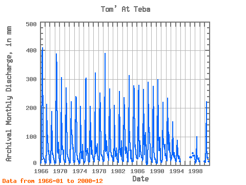
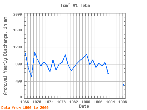
| Year | Jan | Feb | Mar | Apr | May | Jun | Jul | Aug | Sep | Oct | Nov | Dec | Annual | 1966 | 8.56 | 7.18 | 7.82 | 28.60 | 398.93 | 408.76 | 80.65 | 33.80 | 21.93 | 22.78 | 19.96 | 12.31 | 1048.73 | 1967 | 8.93 | 8.58 | 8.93 | 57.50 | 218.55 | 99.51 | 108.97 | 49.31 | 49.34 | 52.33 | 22.70 | 11.82 | 692.26 | 1968 | 9.11 | 7.07 | 9.05 | 89.97 | 193.31 | 52.44 | 40.08 | 43.22 | 28.18 | 21.36 | 13.41 | 9.42 | 514.03 | 1969 | 7.39 | 8.08 | 8.56 | 57.74 | 400.16 | 331.89 | 49.93 | 42.73 | 58.10 | 83.11 | 29.67 | 16.19 | 1090.27 | 1970 | 12.37 | 9.59 | 10.40 | 61.37 | 316.44 | 236.56 | 57.01 | 69.57 | 38.67 | 54.42 | 22.17 | 15.95 | 900.91 | 1971 | 11.94 | 9.37 | 9.60 | 81.63 | 278.88 | 163.86 | 66.49 | 46.23 | 30.51 | 27.52 | 21.03 | 12.50 | 756.53 | 1972 | 12.93 | 8.13 | 8.31 | 102.49 | 228.40 | 123.94 | 126.20 | 91.73 | 55.77 | 64.64 | 22.46 | 10.96 | 851.33 | 1973 | 12.31 | 10.27 | 12.01 | 78.06 | 246.87 | 232.39 | 69.57 | 48.51 | 20.50 | 22.22 | 12.16 | 14.71 | 777.75 | 1974 | 9.48 | 6.45 | 8.68 | 76.87 | 211.16 | 73.29 | 25.86 | 22.96 | 72.69 | 72.64 | 28.72 | 16.75 | 623.16 | 1975 | 12.19 | 8.64 | 8.00 | 17.64 | 309.05 | 304.49 | 58.85 | 35.71 | 46.48 | 59.72 | 25.20 | 18.41 | 901.82 | 1976 | 12.31 | 10.99 | 11.57 | 33.25 | 212.39 | 91.17 | 40.08 | 88.65 | 60.18 | 47.16 | 26.57 | 22.59 | 653.09 | 1977 | 16.87 | 13.63 | 12.74 | 49.10 | 333.06 | 95.93 | 41.12 | 51.65 | 50.23 | 77.57 | 44.57 | 21.86 | 802.97 | 1978 | 18.84 | 17.50 | 16.62 | 140.62 | 259.80 | 185.91 | 51.77 | 42.79 | 33.07 | 36.81 | 25.20 | 14.59 | 842.63 | 1979 | 14.04 | 12.62 | 15.82 | 87.59 | 403.24 | 168.03 | 49.93 | 54.42 | 57.26 | 88.65 | 46.30 | 33.37 | 1025.70 | 1980 | 30.47 | 19.35 | 18.16 | 73.89 | 275.19 | 122.15 | 60.33 | 56.58 | 34.44 | 31.40 | 32.35 | 21.49 | 772.31 | 1981 | 18.47 | 14.13 | 13.42 | 99.51 | 216.09 | 69.72 | 31.40 | 35.65 | 43.98 | 62.18 | 21.75 | 18.90 | 642.63 | 1982 | 15.88 | 11.72 | 11.02 | 97.72 | 266.57 | 79.85 | 47.71 | 41.37 | 31.94 | 88.03 | 41.11 | 20.56 | 749.28 | 1983 | 16.38 | 13.01 | 13.30 | 41.65 | 243.79 | 186.50 | 64.64 | 41.92 | 55.12 | 66.49 | 56.79 | 28.20 | 825.28 | 1984 | 20.99 | 14.98 | 11.45 | 88.19 | 323.21 | 154.92 | 84.34 | 79.42 | 23.00 | 55.53 | 35.45 | 12.99 | 899.52 | 1985 | 12.13 | 15.43 | 14.59 | 58.22 | 286.88 | 261.58 | 65.87 | 79.42 | 67.33 | 45.87 | 26.75 | 24.44 | 956.29 | 1986 | 24.56 | 21.32 | 23.46 | 244.30 | 288.12 | 139.43 | 30.41 | 88.65 | 55.12 | 51.53 | 43.02 | 26.96 | 1036.04 | 1987 | 26.41 | 24.62 | 15.08 | 23.89 | 273.34 | 93.55 | 51.34 | 37.25 | 95.34 | 117.59 | 28.30 | 10.65 | 793.29 | 1988 | 3.46 | 2.24 | 5.99 | 99.51 | 298.58 | 135.86 | 134.21 | 103.43 | 49.46 | 32.75 | 21.63 | 20.38 | 901.42 | 1989 | 14.04 | 10.04 | 11.33 | 113.81 | 285.04 | 132.88 | 52.27 | 34.78 | 20.86 | 23.89 | 16.74 | 10.16 | 723.04 | 1990 | 8.31 | 6.45 | 7.57 | 44.33 | 307.82 | 118.58 | 52.39 | 52.08 | 97.72 | 101.58 | 19.72 | 11.82 | 823.28 | 1991 | 10.10 | 9.93 | 12.37 | 24.97 | 227.17 | 113.81 | 75.72 | 70.80 | 57.02 | 74.49 | 33.07 | 42.17 | 746.56 | 1992 | 27.89 | 15.20 | 16.07 | 70.91 | 241.33 | 93.55 | 54.30 | 120.05 | 100.11 | 57.69 | 33.78 | 19.39 | 846.20 | 1993 | 16.56 | 17.89 | 28.26 | 43.91 | 139.13 | 150.75 | 38.05 | 30.78 | 27.95 | 44.57 | 24.19 | 21.18 | 582.53 | 1994 | 12.44 | 12.56 | 17.85 | 51.19 | 90.50 | 34.68 | 23.58 | 24.32 | 33.01 | 28.44 | 19.66 | 13.61 | 361.07 | 1997 | 29.18 | 25.97 | 29.12 | 42.66 | 33.49 | 34.11 | 35.63 | 33.18 | 1998 | 8.00 | 6.96 | 8.31 | 14.66 | 102.19 | 44.63 | 24.38 | 21.67 | 20.38 | 26.59 | 19.37 | 14.47 | 309.92 | 2000 | 13.11 | 11.55 | 9.73 | 72.69 | 228.40 | 64.95 | 32.94 | 26.72 | 24.31 | 22.22 | 13.71 | 10.65 | 528.30 |
|---|
 Return to R-Arctic Net Home Page