|
|
|||||||||||||||||
| Point ID: 6758 | Downloads | Plots | Site Data | Code: 10233 |
|
|
|||||||||||||||||
| Download | |
|---|---|
| Site Descriptor Information | Site Time Series Data |
| Link to all available data | |
| View: | Time Series | All |
| Units: | mm |
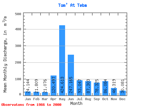
| Statistic | Jan | Feb | Mar | Apr | May | Jun | Jul | Aug | Sep | Oct | Nov | Dec | Annual |
|---|---|---|---|---|---|---|---|---|---|---|---|---|---|
| Mean | 24.14 | 21.81 | 21.08 | 120.50 | 424.61 | 247.16 | 93.05 | 87.30 | 78.33 | 86.08 | 46.32 | 30.08 | 106.61 |
| Standard Deviation | 10.97 | 9.64 | 9.12 | 74.13 | 120.79 | 147.47 | 43.55 | 41.04 | 37.37 | 41.39 | 17.45 | 12.59 | 25.71 |
| Min | 5.62 | 3.99 | 9.73 | 24.60 | 147.00 | 58.20 | 38.30 | 35.20 | 34.20 | 34.70 | 20.40 | 15.30 | 42.72 |
| Max | 49.50 | 46.30 | 47.30 | 410.00 | 655.00 | 686.00 | 218.00 | 195.00 | 168.00 | 191.00 | 95.30 | 68.50 | 150.28 |
| Coefficient of Variation | 0.45 | 0.44 | 0.43 | 0.61 | 0.28 | 0.60 | 0.47 | 0.47 | 0.48 | 0.48 | 0.38 | 0.42 | 0.24 |
 Return to R-Arctic Net Home Page