|
|
|||||||||||||||||
| Point ID: 6677 | Downloads | Plots | Site Data | Code: 10059 |
|
|
|||||||||||||||||
| Download | |
|---|---|
| Site Descriptor Information | Site Time Series Data |
| Link to all available data | |
| View: | Time Series | All |
| Units: | m3/s |
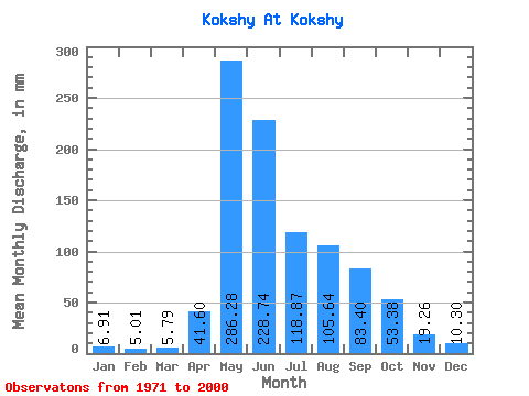
| Statistic | Jan | Feb | Mar | Apr | May | Jun | Jul | Aug | Sep | Oct | Nov | Dec | Annual |
|---|---|---|---|---|---|---|---|---|---|---|---|---|---|
| Mean | 6.91 | 5.05 | 5.79 | 41.60 | 286.24 | 228.74 | 118.85 | 105.62 | 83.40 | 53.37 | 19.26 | 10.30 | 944.51 |
| Standard Deviation | 1.35 | 1.18 | 2.27 | 33.03 | 58.85 | 108.33 | 57.48 | 55.22 | 35.25 | 24.29 | 5.58 | 2.72 | 140.07 |
| Min | 2.78 | 2.74 | 3.40 | 10.32 | 185.53 | 97.75 | 42.16 | 25.93 | 35.09 | 24.06 | 10.10 | 3.86 | 644.68 |
| Max | 9.47 | 7.75 | 14.30 | 169.69 | 400.56 | 537.62 | 287.09 | 239.43 | 160.90 | 135.03 | 32.95 | 15.38 | 1295.22 |
| Coefficient of Variation | 0.20 | 0.23 | 0.39 | 0.79 | 0.21 | 0.47 | 0.48 | 0.52 | 0.42 | 0.46 | 0.29 | 0.26 | 0.15 |
 Return to R-Arctic Net Home Page