|
|
|||||||||||||||||
| Point ID: 6677 | Downloads | Plots | Site Data | Code: 10059 |
|
|
|||||||||||||||||
| Download | |
|---|---|
| Site Descriptor Information | Site Time Series Data |
| Link to all available data | |
| View: | Time Series | All |
| Units: | mm |
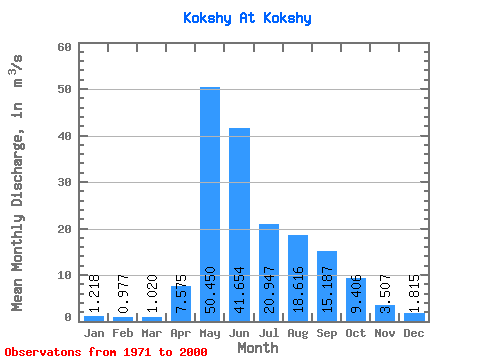
| Statistic | Jan | Feb | Mar | Apr | May | Jun | Jul | Aug | Sep | Oct | Nov | Dec | Annual |
|---|---|---|---|---|---|---|---|---|---|---|---|---|---|
| Mean | 1.22 | 0.98 | 1.02 | 7.58 | 50.45 | 41.65 | 20.95 | 18.62 | 15.19 | 9.41 | 3.51 | 1.81 | 14.13 |
| Standard Deviation | 0.24 | 0.23 | 0.40 | 6.01 | 10.37 | 19.73 | 10.13 | 9.73 | 6.42 | 4.28 | 1.01 | 0.48 | 2.10 |
| Min | 0.49 | 0.53 | 0.60 | 1.88 | 32.70 | 17.80 | 7.43 | 4.57 | 6.39 | 4.24 | 1.84 | 0.68 | 9.64 |
| Max | 1.67 | 1.50 | 2.52 | 30.90 | 70.60 | 97.90 | 50.60 | 42.20 | 29.30 | 23.80 | 6.00 | 2.71 | 19.37 |
| Coefficient of Variation | 0.20 | 0.23 | 0.39 | 0.79 | 0.21 | 0.47 | 0.48 | 0.52 | 0.42 | 0.46 | 0.29 | 0.26 | 0.15 |
 Return to R-Arctic Net Home Page