|
|
|||||||||||||||||
| Point ID: 6677 | Downloads | Plots | Site Data | Code: 10059 |
|
|
|||||||||||||||||
| Download | |
|---|---|
| Site Descriptor Information | Site Time Series Data |
| Link to all available data | |
|
|
| View: | Statistics | Time Series |
| Units: | m3/s |
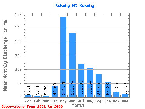
| Statistic | Jan | Feb | Mar | Apr | May | Jun | Jul | Aug | Sep | Oct | Nov | Dec | Annual |
|---|---|---|---|---|---|---|---|---|---|---|---|---|---|
| Mean | 6.91 | 5.05 | 5.79 | 41.60 | 286.24 | 228.74 | 118.85 | 105.62 | 83.40 | 53.37 | 19.26 | 10.30 | 944.51 |
| Standard Deviation | 1.35 | 1.18 | 2.27 | 33.03 | 58.85 | 108.33 | 57.48 | 55.22 | 35.25 | 24.29 | 5.58 | 2.72 | 140.07 |
| Min | 2.78 | 2.74 | 3.40 | 10.32 | 185.53 | 97.75 | 42.16 | 25.93 | 35.09 | 24.06 | 10.10 | 3.86 | 644.68 |
| Max | 9.47 | 7.75 | 14.30 | 169.69 | 400.56 | 537.62 | 287.09 | 239.43 | 160.90 | 135.03 | 32.95 | 15.38 | 1295.22 |
| Coefficient of Variation | 0.20 | 0.23 | 0.39 | 0.79 | 0.21 | 0.47 | 0.48 | 0.52 | 0.42 | 0.46 | 0.29 | 0.26 | 0.15 |
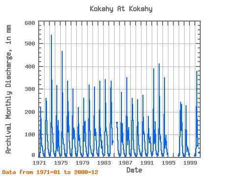
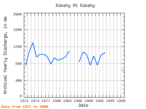
| Year | Jan | Feb | Mar | Apr | May | Jun | Jul | Aug | Sep | Oct | Nov | Dec | Annual | 1971 | 5.73 | 3.52 | 4.14 | 32.95 | 209.36 | 218.56 | 125.39 | 49.36 | 49.59 | 38.98 | 17.35 | 7.21 | 759.19 | 1972 | 5.79 | 3.83 | 4.25 | 63.15 | 267.80 | 235.04 | 225.81 | 108.37 | 90.61 | 46.24 | 21.75 | 14.30 | 1081.20 | 1973 | 7.15 | 5.69 | 5.45 | 42.06 | 271.20 | 537.62 | 146.95 | 122.55 | 92.26 | 34.04 | 18.18 | 12.26 | 1295.22 | 1974 | 5.33 | 3.83 | 4.99 | 49.97 | 325.11 | 225.15 | 52.20 | 28.20 | 160.90 | 73.19 | 22.24 | 7.77 | 957.00 | 1975 | 7.09 | 4.96 | 4.88 | 10.32 | 219.01 | 464.58 | 105.53 | 66.38 | 57.11 | 55.20 | 13.84 | 5.50 | 1014.50 | 1976 | 6.07 | 4.45 | 4.37 | 25.26 | 346.10 | 155.96 | 115.18 | 206.52 | 78.53 | 60.71 | 16.48 | 8.79 | 1019.40 | 1977 | 7.60 | 5.89 | 5.50 | 65.90 | 309.79 | 168.59 | 82.84 | 131.63 | 108.73 | 67.52 | 17.96 | 8.79 | 975.50 | 1978 | 6.13 | 4.08 | 4.54 | 46.51 | 225.81 | 215.82 | 76.59 | 98.16 | 70.29 | 24.96 | 14.44 | 7.04 | 791.84 | 1979 | 4.99 | 3.88 | 4.14 | 15.05 | 268.37 | 149.37 | 72.62 | 157.16 | 157.61 | 59.57 | 32.84 | 11.91 | 932.65 | 1980 | 7.38 | 4.39 | 3.80 | 21.31 | 326.81 | 183.42 | 187.80 | 52.82 | 43.33 | 24.06 | 16.80 | 11.46 | 876.59 | 1981 | 7.60 | 5.48 | 6.47 | 55.46 | 317.73 | 114.77 | 99.86 | 127.09 | 96.10 | 50.10 | 18.40 | 12.43 | 904.95 | 1982 | 8.28 | 6.62 | 6.24 | 82.92 | 344.96 | 162.00 | 95.89 | 103.83 | 39.32 | 73.76 | 21.36 | 11.57 | 950.20 | 1983 | 8.45 | 6.20 | 7.49 | 10.43 | 219.01 | 341.57 | 141.28 | 125.39 | 106.54 | 82.84 | 24.38 | 10.16 | 1080.64 | 1984 | 7.26 | 4.91 | 5.56 | 23.01 | 282.55 | 334.98 | 287.09 | 209.36 | 53.98 | 72.06 | 1985 | 156.59 | 107.08 | 38.81 | 17.35 | 10.33 | 1986 | 7.04 | 4.91 | 6.07 | 18.56 | 295.03 | 164.20 | 70.92 | 151.49 | 65.90 | 46.30 | 17.41 | 12.31 | 853.86 | 1987 | 7.83 | 4.91 | 4.03 | 14.33 | 361.98 | 265.79 | 93.05 | 57.30 | 104.34 | 135.03 | 18.84 | 12.03 | 1073.73 | 1988 | 9.47 | 6.56 | 5.62 | 60.96 | 268.37 | 244.37 | 224.68 | 110.07 | 43.93 | 26.55 | 15.05 | 8.74 | 1018.51 | 1989 | 6.41 | 4.03 | 4.14 | 16.42 | 262.13 | 184.51 | 127.09 | 73.19 | 35.09 | 35.40 | 14.22 | 9.53 | 766.88 | 1990 | 7.72 | 4.70 | 5.56 | 42.06 | 281.42 | 249.31 | 104.96 | 115.74 | 91.16 | 53.16 | 15.76 | 9.47 | 976.89 | 1991 | 6.75 | 5.17 | 4.65 | 24.93 | 185.53 | 156.51 | 100.42 | 65.25 | 77.98 | 92.48 | 32.95 | 13.90 | 762.81 | 1992 | 6.41 | 7.75 | 14.30 | 37.95 | 400.56 | 180.67 | 60.14 | 69.79 | 155.96 | 48.45 | 13.95 | 11.80 | 1003.08 | 1993 | 8.23 | 6.62 | 7.77 | 38.55 | 216.17 | 410.22 | 124.82 | 80.00 | 91.16 | 43.23 | 16.53 | 8.51 | 1051.72 | 1994 | 6.47 | 4.39 | 5.73 | 26.20 | 361.98 | 97.75 | 42.16 | 68.65 | 95.00 | 46.52 | 25.86 | 15.38 | 790.23 | 1997 | 8.17 | 6.41 | 9.59 | 169.69 | 249.64 | 117.52 | 120.28 | 239.43 | 73.59 | 24.96 | 10.10 | 3.86 | 1027.43 | 1998 | 2.78 | 2.74 | 3.40 | 18.89 | 235.46 | 159.80 | 76.59 | 25.93 | 43.60 | 39.43 | 27.02 | 12.26 | 644.68 | 2000 | 7.49 | 5.33 | 7.83 | 68.64 | 390.35 | 209.23 | 129.93 | 51.57 | 62.05 | 47.38 | 19.66 | 10.50 | 1004.08 |
|---|
 Return to R-Arctic Net Home Page