|
|
|||||||||||||||||
| Point ID: 6676 | Downloads | Plots | Site Data | Code: 10058 |
|
|
|||||||||||||||||
| Download | |
|---|---|
| Site Descriptor Information | Site Time Series Data |
| Link to all available data | |
| View: | Time Series | All |
| Units: | m3/s |
| Statistic | Jan | Feb | Mar | Apr | May | Jun | Jul | Aug | Sep | Oct | Nov | Dec | Annual |
|---|---|---|---|---|---|---|---|---|---|---|---|---|---|
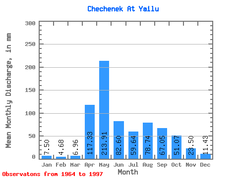
| Mean | 7.43 | 4.70 | 6.88 | 117.34 | 213.85 | 82.67 | 59.56 | 78.74 | 67.10 | 51.12 | 23.54 | 11.46 | 721.64 |
| Standard Deviation | 2.48 | 1.39 | 5.11 | 47.80 | 135.73 | 46.38 | 40.48 | 55.83 | 39.39 | 27.94 | 10.38 | 4.35 | 186.78 |
| Min | 3.75 | 1.30 | 2.50 | 43.20 | 67.84 | 10.20 | 11.78 | 15.00 | 16.59 | 13.93 | 9.50 | 3.39 | 466.39 |
| Max | 13.57 | 8.13 | 32.14 | 212.54 | 719.49 | 193.54 | 205.31 | 244.59 | 139.97 | 123.19 | 58.75 | 23.21 | 1377.94 |
| Coefficient of Variation | 0.33 | 0.29 | 0.74 | 0.41 | 0.64 | 0.56 | 0.68 | 0.71 | 0.59 | 0.55 | 0.44 | 0.38 | 0.26 |
 Return to R-Arctic Net Home Page