|
|
|||||||||||||||||
| Point ID: 6676 | Downloads | Plots | Site Data | Code: 10058 |
|
|
|||||||||||||||||
| Download | |
|---|---|
| Site Descriptor Information | Site Time Series Data |
| Link to all available data | |
|
|
| View: | Statistics | Time Series |
| Units: | m3/s |
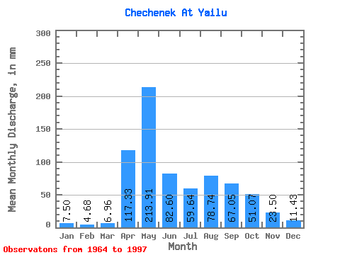
| Statistic | Jan | Feb | Mar | Apr | May | Jun | Jul | Aug | Sep | Oct | Nov | Dec | Annual |
|---|---|---|---|---|---|---|---|---|---|---|---|---|---|
| Mean | 7.43 | 4.70 | 6.88 | 117.34 | 213.85 | 82.67 | 59.56 | 78.74 | 67.10 | 51.12 | 23.54 | 11.46 | 721.64 |
| Standard Deviation | 2.48 | 1.39 | 5.11 | 47.80 | 135.73 | 46.38 | 40.48 | 55.83 | 39.39 | 27.94 | 10.38 | 4.35 | 186.78 |
| Min | 3.75 | 1.30 | 2.50 | 43.20 | 67.84 | 10.20 | 11.78 | 15.00 | 16.59 | 13.93 | 9.50 | 3.39 | 466.39 |
| Max | 13.57 | 8.13 | 32.14 | 212.54 | 719.49 | 193.54 | 205.31 | 244.59 | 139.97 | 123.19 | 58.75 | 23.21 | 1377.94 |
| Coefficient of Variation | 0.33 | 0.29 | 0.74 | 0.41 | 0.64 | 0.56 | 0.68 | 0.71 | 0.59 | 0.55 | 0.44 | 0.38 | 0.26 |
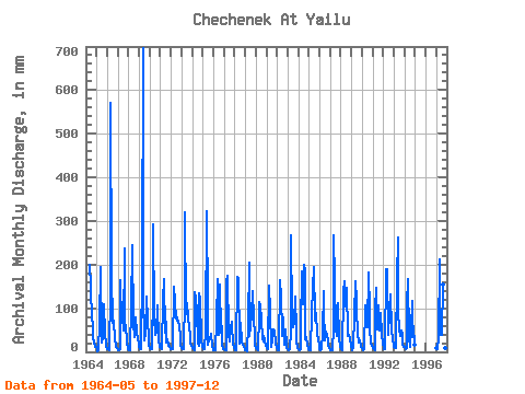
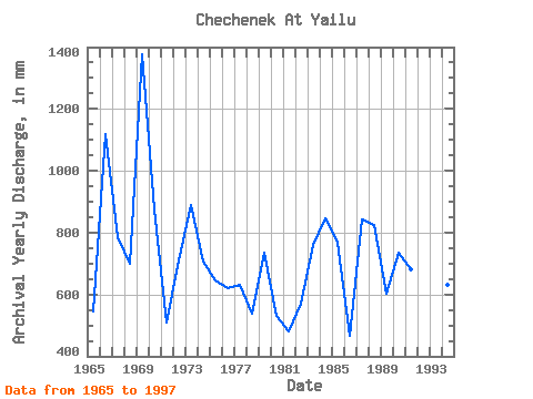
| Year | Jan | Feb | Mar | Apr | May | Jun | Jul | Aug | Sep | Oct | Nov | Dec | Annual | 1964 | 205.31 | 150.34 | 74.98 | 67.84 | 32.83 | 23.21 | 12.10 | 10.89 | 1965 | 6.61 | 1.30 | 5.18 | 67.39 | 199.96 | 27.65 | 23.21 | 35.71 | 108.86 | 39.28 | 22.46 | 10.53 | 545.81 | 1966 | 7.32 | 5.53 | 4.82 | 134.78 | 590.95 | 177.98 | 67.84 | 74.98 | 27.65 | 16.25 | 12.10 | 8.21 | 1120.20 | 1967 | 4.29 | 2.93 | 6.43 | 164.16 | 67.84 | 100.22 | 51.77 | 244.59 | 55.30 | 64.27 | 20.74 | 5.71 | 785.49 | 1968 | 4.29 | 4.07 | 7.86 | 101.95 | 253.52 | 65.66 | 35.71 | 49.99 | 79.49 | 48.20 | 29.38 | 23.21 | 700.11 | 1969 | 13.57 | 4.88 | 6.96 | 186.62 | 719.49 | 129.60 | 26.78 | 46.42 | 127.87 | 74.98 | 32.83 | 16.78 | 1377.94 | 1970 | 9.64 | 6.34 | 5.89 | 138.24 | 301.72 | 79.49 | 41.06 | 46.42 | 105.41 | 108.91 | 25.92 | 12.50 | 877.72 | 1971 | 8.39 | 5.69 | 8.03 | 119.23 | 171.39 | 43.20 | 71.41 | 21.42 | 27.65 | 13.93 | 12.96 | 6.96 | 508.29 | 1972 | 5.71 | 5.86 | 7.50 | 148.61 | 117.83 | 76.03 | 92.84 | 74.98 | 70.85 | 57.13 | 36.29 | 17.85 | 710.10 | 1973 | 9.82 | 6.51 | 6.78 | 129.60 | 330.29 | 86.40 | 116.05 | 82.12 | 55.30 | 37.49 | 20.74 | 13.75 | 888.94 | 1974 | 9.82 | 5.69 | 4.82 | 136.51 | 124.97 | 91.58 | 21.42 | 15.00 | 133.06 | 123.19 | 27.65 | 12.50 | 706.77 | 1975 | 7.32 | 5.37 | 6.43 | 50.11 | 332.07 | 108.86 | 17.85 | 30.35 | 29.38 | 42.85 | 13.48 | 7.14 | 646.63 | 1976 | 4.46 | 2.93 | 3.39 | 70.85 | 171.39 | 44.93 | 39.28 | 160.68 | 44.93 | 60.70 | 15.72 | 7.32 | 621.38 | 1977 | 5.36 | 3.90 | 3.93 | 160.70 | 180.32 | 39.74 | 25.00 | 57.13 | 69.12 | 57.13 | 22.46 | 8.21 | 631.55 | 1978 | 5.18 | 4.39 | 5.36 | 171.07 | 174.96 | 19.01 | 32.14 | 69.63 | 22.46 | 16.60 | 13.13 | 6.07 | 538.10 | 1979 | 4.82 | 3.58 | 2.50 | 63.94 | 210.67 | 36.29 | 58.92 | 89.27 | 139.97 | 78.56 | 36.29 | 15.71 | 736.58 | 1980 | 8.03 | 5.21 | 3.75 | 84.67 | 117.83 | 105.41 | 73.20 | 32.14 | 24.19 | 37.49 | 25.92 | 14.46 | 531.09 | 1981 | 8.21 | 4.88 | 6.07 | 152.06 | 98.19 | 10.20 | 28.57 | 42.85 | 51.84 | 49.99 | 19.01 | 8.03 | 479.36 | 1982 | 5.36 | 4.39 | 5.00 | 164.16 | 128.54 | 50.11 | 37.49 | 82.12 | 16.59 | 53.56 | 17.11 | 9.64 | 572.29 | 1983 | 6.43 | 4.23 | 7.50 | 50.11 | 276.73 | 84.67 | 57.13 | 67.84 | 127.87 | 49.99 | 24.19 | 8.93 | 761.65 | 1984 | 6.43 | 2.77 | 6.61 | 55.30 | 191.03 | 108.86 | 205.31 | 191.03 | 29.38 | 33.92 | 15.90 | 6.61 | 844.93 | 1985 | 3.75 | 3.58 | 3.75 | 89.86 | 151.75 | 193.54 | 76.77 | 73.20 | 88.13 | 41.06 | 29.38 | 13.75 | 768.13 | 1986 | 6.25 | 3.42 | 5.36 | 43.20 | 142.83 | 100.22 | 26.78 | 48.20 | 36.29 | 30.35 | 17.28 | 7.86 | 466.39 | 1987 | 5.00 | 4.23 | 3.93 | 55.30 | 274.94 | 162.43 | 55.34 | 37.49 | 88.13 | 116.05 | 31.10 | 12.32 | 842.48 | 1988 | 7.50 | 3.90 | 4.29 | 136.51 | 166.04 | 103.68 | 137.47 | 151.75 | 36.29 | 39.28 | 29.38 | 13.03 | 824.59 | 1989 | 6.78 | 3.90 | 12.14 | 82.94 | 167.82 | 117.50 | 96.41 | 44.63 | 20.74 | 26.78 | 12.79 | 12.68 | 602.27 | 1990 | 8.75 | 4.39 | 6.43 | 101.95 | 110.69 | 79.49 | 57.13 | 187.46 | 95.04 | 53.56 | 20.74 | 13.75 | 736.23 | 1991 | 8.03 | 6.34 | 5.18 | 96.77 | 151.75 | 51.84 | 108.91 | 49.99 | 55.30 | 92.84 | 41.47 | 16.43 | 681.17 | 1992 | 11.43 | 6.02 | 6.07 | 190.08 | 196.39 | 41.47 | 41.06 | 91.05 | 131.33 | 53.56 | 27.65 | 15.89 | 810.74 | 1993 | 11.96 | 8.13 | 10.18 | 169.34 | 271.37 | 88.13 | 55.34 | 37.49 | 50.11 | 39.28 | 19.01 | 10.71 | 768.66 | 1994 | 10.89 | 6.02 | 8.93 | 108.86 | 173.18 | 31.10 | 11.78 | 55.34 | 117.50 | 33.92 | 58.75 | 16.07 | 631.90 | 1997 | 8.93 | 5.21 | 32.14 | 212.54 | 71.41 | 39.74 | 41.06 | 160.68 | 48.38 | 21.42 | 9.50 | 3.39 | 653.29 |
|---|
 Return to R-Arctic Net Home Page