|
|
|||||||||||||||||
| Point ID: 6676 | Downloads | Plots | Site Data | Code: 10058 |
|
|
|||||||||||||||||
| Download | |
|---|---|
| Site Descriptor Information | Site Time Series Data |
| Link to all available data | |
| View: | Time Series | All |
| Units: | mm |
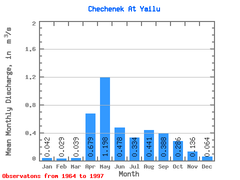
| Statistic | Jan | Feb | Mar | Apr | May | Jun | Jul | Aug | Sep | Oct | Nov | Dec | Annual |
|---|---|---|---|---|---|---|---|---|---|---|---|---|---|
| Mean | 0.04 | 0.03 | 0.04 | 0.68 | 1.20 | 0.48 | 0.33 | 0.44 | 0.39 | 0.29 | 0.14 | 0.06 | 0.34 |
| Standard Deviation | 0.01 | 0.01 | 0.03 | 0.28 | 0.76 | 0.27 | 0.23 | 0.31 | 0.23 | 0.16 | 0.06 | 0.02 | 0.09 |
| Min | 0.02 | 0.01 | 0.01 | 0.25 | 0.38 | 0.06 | 0.07 | 0.08 | 0.10 | 0.08 | 0.06 | 0.02 | 0.22 |
| Max | 0.08 | 0.05 | 0.18 | 1.23 | 4.03 | 1.12 | 1.15 | 1.37 | 0.81 | 0.69 | 0.34 | 0.13 | 0.66 |
| Coefficient of Variation | 0.33 | 0.29 | 0.74 | 0.41 | 0.64 | 0.56 | 0.68 | 0.71 | 0.59 | 0.55 | 0.44 | 0.38 | 0.26 |
 Return to R-Arctic Net Home Page