|
|
|||||||||||||||||
| Point ID: 6624 | Downloads | Plots | Site Data | Code: 9408 |
|
|
|||||||||||||||||
| Download | |
|---|---|
| Site Descriptor Information | Site Time Series Data |
| Link to all available data | |
| View: | Time Series | All |
| Units: | m3/s |
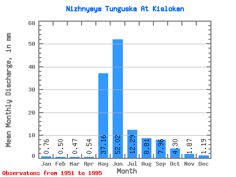
| Statistic | Jan | Feb | Mar | Apr | May | Jun | Jul | Aug | Sep | Oct | Nov | Dec | Annual |
|---|---|---|---|---|---|---|---|---|---|---|---|---|---|
| Mean | 0.76 | 0.51 | 0.47 | 0.54 | 37.15 | 52.02 | 12.29 | 8.80 | 7.96 | 4.30 | 1.87 | 1.19 | 127.66 |
| Standard Deviation | 0.30 | 0.21 | 0.21 | 0.39 | 14.58 | 21.11 | 6.02 | 5.97 | 4.99 | 2.38 | 0.84 | 0.49 | 28.83 |
| Min | 0.25 | 0.17 | 0.13 | 0.12 | 11.82 | 19.73 | 3.78 | 2.69 | 1.94 | 1.47 | 0.68 | 0.39 | 87.82 |
| Max | 1.45 | 0.94 | 0.89 | 2.21 | 72.22 | 110.20 | 25.40 | 29.72 | 23.08 | 9.26 | 4.42 | 2.28 | 199.28 |
| Coefficient of Variation | 0.40 | 0.42 | 0.45 | 0.73 | 0.39 | 0.41 | 0.49 | 0.68 | 0.63 | 0.55 | 0.45 | 0.42 | 0.23 |
 Return to R-Arctic Net Home Page