|
|
|||||||||||||||||
| Point ID: 6624 | Downloads | Plots | Site Data | Code: 9408 |
|
|
|||||||||||||||||
| Download | |
|---|---|
| Site Descriptor Information | Site Time Series Data |
| Link to all available data | |
| View: | Time Series | All |
| Units: | mm |
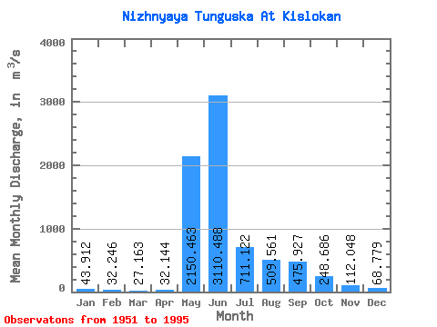
| Statistic | Jan | Feb | Mar | Apr | May | Jun | Jul | Aug | Sep | Oct | Nov | Dec | Annual |
|---|---|---|---|---|---|---|---|---|---|---|---|---|---|
| Mean | 43.91 | 32.25 | 27.16 | 32.14 | 2150.46 | 3110.49 | 711.12 | 509.56 | 475.93 | 248.69 | 112.05 | 68.78 | 626.97 |
| Standard Deviation | 17.43 | 13.53 | 12.10 | 23.42 | 844.00 | 1262.19 | 348.60 | 345.62 | 298.43 | 137.83 | 50.00 | 28.58 | 141.57 |
| Min | 14.70 | 10.90 | 7.37 | 6.86 | 684.00 | 1180.00 | 219.00 | 156.00 | 116.00 | 85.10 | 40.80 | 22.40 | 431.29 |
| Max | 83.80 | 59.70 | 51.50 | 132.00 | 4180.00 | 6590.00 | 1470.00 | 1720.00 | 1380.00 | 536.00 | 264.00 | 132.00 | 978.73 |
| Coefficient of Variation | 0.40 | 0.42 | 0.45 | 0.73 | 0.39 | 0.41 | 0.49 | 0.68 | 0.63 | 0.55 | 0.45 | 0.42 | 0.23 |
 Return to R-Arctic Net Home Page