|
|
|||||||||||||||||
| Point ID: 590 | Downloads | Plots | Site Data | Code: 07AB002 |
|
|
|||||||||||||||||
| Download | |
|---|---|
| Site Descriptor Information | Site Time Series Data |
| Link to all available data | |
| View: | Time Series | All |
| Units: | m3/s |
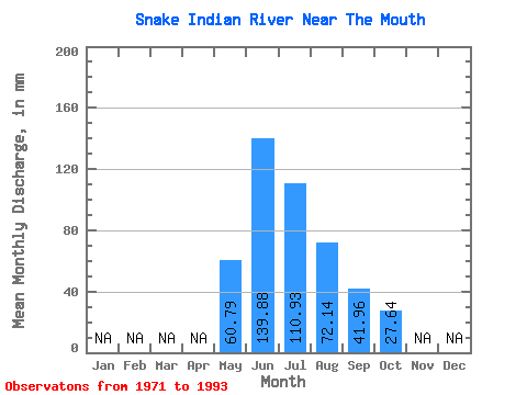
| Statistic | Jan | Feb | Mar | Apr | May | Jun | Jul | Aug | Sep | Oct | Nov | Dec | Annual |
|---|---|---|---|---|---|---|---|---|---|---|---|---|---|
| Mean | 60.78 | 139.88 | 110.92 | 72.13 | 41.96 | 27.64 | |||||||
| Standard Deviation | 18.65 | 59.21 | 30.88 | 19.68 | 10.74 | 7.17 | |||||||
| Min | 23.56 | 69.72 | 57.12 | 47.29 | 28.71 | 18.48 | |||||||
| Max | 87.80 | 344.51 | 174.58 | 124.75 | 70.21 | 40.17 | |||||||
| Coefficient of Variation | 0.31 | 0.42 | 0.28 | 0.27 | 0.26 | 0.26 |
 Return to R-Arctic Net Home Page