|
|
|||||||||||||||||
| Point ID: 590 | Downloads | Plots | Site Data | Code: 07AB002 |
|
|
|||||||||||||||||
| Download | |
|---|---|
| Site Descriptor Information | Site Time Series Data |
| Link to all available data | |
| View: | Time Series | All |
| Units: | mm |
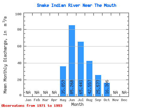
| Statistic | Jan | Feb | Mar | Apr | May | Jun | Jul | Aug | Sep | Oct | Nov | Dec | Annual |
|---|---|---|---|---|---|---|---|---|---|---|---|---|---|
| Mean | 35.86 | 85.27 | 65.44 | 42.56 | 25.58 | 16.31 | |||||||
| Standard Deviation | 11.00 | 36.09 | 18.22 | 11.61 | 6.55 | 4.23 | |||||||
| Min | 13.90 | 42.50 | 33.70 | 27.90 | 17.50 | 10.90 | |||||||
| Max | 51.80 | 210.00 | 103.00 | 73.60 | 42.80 | 23.70 | |||||||
| Coefficient of Variation | 0.31 | 0.42 | 0.28 | 0.27 | 0.26 | 0.26 |
 Return to R-Arctic Net Home Page