|
|
|||||||||||||||||
| Point ID: 5857 | Downloads | Plots | Site Data | Other Close Sites | Code: 1005 |
|
|
|||||||||||||||||
| Download | |
|---|---|
| Site Descriptor Information | Site Time Series Data |
| Link to all available data | |
| View: | Time Series | All |
| Units: | m3/s |
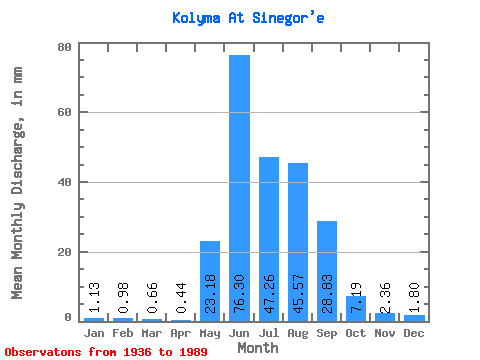
| Statistic | Jan | Feb | Mar | Apr | May | Jun | Jul | Aug | Sep | Oct | Nov | Dec | Annual |
|---|---|---|---|---|---|---|---|---|---|---|---|---|---|
| Mean | 1.13 | 0.99 | 0.66 | 0.44 | 23.18 | 76.30 | 47.25 | 45.57 | 28.84 | 7.18 | 2.36 | 1.80 | 235.29 |
| Standard Deviation | 2.26 | 2.09 | 1.96 | 1.56 | 17.17 | 43.16 | 20.22 | 21.34 | 16.47 | 4.24 | 1.87 | 2.62 | 63.63 |
| Min | 0.11 | 0.03 | 0.02 | 0.02 | 1.40 | 10.12 | 9.28 | 15.28 | 6.28 | 1.99 | 0.11 | 0.12 | 98.72 |
| Max | 12.37 | 8.81 | 11.63 | 9.53 | 78.82 | 175.33 | 112.34 | 102.33 | 75.02 | 22.34 | 9.48 | 11.93 | 357.07 |
| Coefficient of Variation | 2.01 | 2.11 | 2.99 | 3.52 | 0.74 | 0.57 | 0.43 | 0.47 | 0.57 | 0.59 | 0.79 | 1.45 | 0.27 |
| Other Close Sites | ||||||
|---|---|---|---|---|---|---|
| PointID | Latitude | Longitude | Drainage Area | Source | Name | |
| 5878 | "Bokhalcha At 5.4 km from ust'ya" | 62.10 | 2678112 | SHI | 5.40 | |
 Return to R-Arctic Net Home Page