|
|
|||||||||||||||||
| Point ID: 5857 | Downloads | Plots | Site Data | Other Close Sites | Code: 1005 |
|
|
|||||||||||||||||
| Download | |
|---|---|
| Site Descriptor Information | Site Time Series Data |
| Link to all available data | |
| View: | Time Series | All |
| Units: | mm |
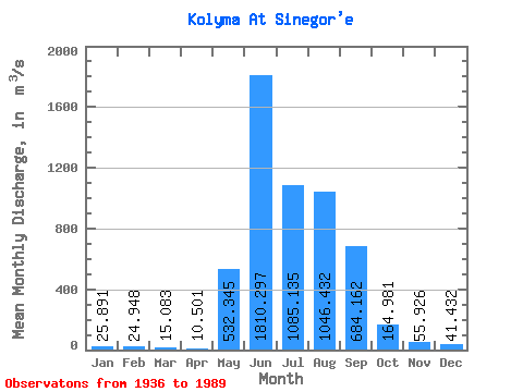
| Statistic | Jan | Feb | Mar | Apr | May | Jun | Jul | Aug | Sep | Oct | Nov | Dec | Annual |
|---|---|---|---|---|---|---|---|---|---|---|---|---|---|
| Mean | 25.89 | 24.95 | 15.08 | 10.50 | 532.35 | 1810.30 | 1085.13 | 1046.43 | 684.16 | 164.98 | 55.93 | 41.43 | 458.51 |
| Standard Deviation | 51.93 | 52.74 | 45.08 | 36.96 | 394.28 | 1024.10 | 464.42 | 490.09 | 390.83 | 97.35 | 44.38 | 60.05 | 123.98 |
| Min | 2.55 | 0.67 | 0.39 | 0.40 | 32.10 | 240.00 | 213.00 | 351.00 | 149.00 | 45.80 | 2.55 | 2.87 | 192.38 |
| Max | 284.00 | 222.00 | 267.00 | 226.00 | 1810.00 | 4160.00 | 2580.00 | 2350.00 | 1780.00 | 513.00 | 225.00 | 274.00 | 695.81 |
| Coefficient of Variation | 2.01 | 2.11 | 2.99 | 3.52 | 0.74 | 0.57 | 0.43 | 0.47 | 0.57 | 0.59 | 0.79 | 1.45 | 0.27 |
| Other Close Sites | ||||||
|---|---|---|---|---|---|---|
| PointID | Latitude | Longitude | Drainage Area | Source | Name | |
| 5878 | "Bokhalcha At 5.4 km from ust'ya" | 62.10 | 2678112 | SHI | 5.40 | |
 Return to R-Arctic Net Home Page