|
|
|||||||||||||||||
| Point ID: 5857 | Downloads | Plots | Site Data | Other Close Sites | Code: 1005 |
|
|
|||||||||||||||||
| Download | |
|---|---|
| Site Descriptor Information | Site Time Series Data |
| Link to all available data | |
|
|
| View: | Statistics | Time Series |
| Units: | m3/s |
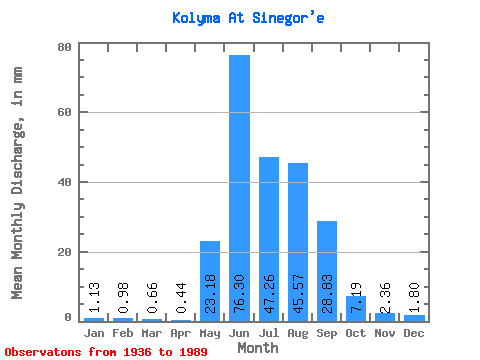
| Statistic | Jan | Feb | Mar | Apr | May | Jun | Jul | Aug | Sep | Oct | Nov | Dec | Annual |
|---|---|---|---|---|---|---|---|---|---|---|---|---|---|
| Mean | 1.13 | 0.99 | 0.66 | 0.44 | 23.18 | 76.30 | 47.25 | 45.57 | 28.84 | 7.18 | 2.36 | 1.80 | 235.29 |
| Standard Deviation | 2.26 | 2.09 | 1.96 | 1.56 | 17.17 | 43.16 | 20.22 | 21.34 | 16.47 | 4.24 | 1.87 | 2.62 | 63.63 |
| Min | 0.11 | 0.03 | 0.02 | 0.02 | 1.40 | 10.12 | 9.28 | 15.28 | 6.28 | 1.99 | 0.11 | 0.12 | 98.72 |
| Max | 12.37 | 8.81 | 11.63 | 9.53 | 78.82 | 175.33 | 112.34 | 102.33 | 75.02 | 22.34 | 9.48 | 11.93 | 357.07 |
| Coefficient of Variation | 2.01 | 2.11 | 2.99 | 3.52 | 0.74 | 0.57 | 0.43 | 0.47 | 0.57 | 0.59 | 0.79 | 1.45 | 0.27 |
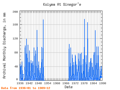
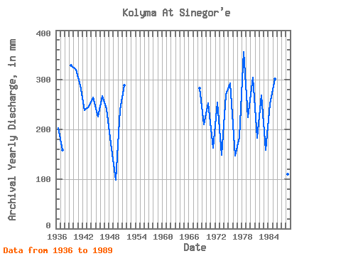
| Year | Jan | Feb | Mar | Apr | May | Jun | Jul | Aug | Sep | Oct | Nov | Dec | Annual | 1936 | 0.61 | 0.29 | 0.11 | 0.12 | 36.32 | 46.36 | 33.01 | 36.80 | 39.11 | 7.53 | 1.98 | 1.04 | 202.51 | 1937 | 0.37 | 0.18 | 0.07 | 0.07 | 5.01 | 34.22 | 54.87 | 40.10 | 17.74 | 5.57 | 1.25 | 0.76 | 159.10 | 1938 | 0.51 | 0.25 | 0.09 | 0.41 | 17.16 | 1939 | 0.27 | 0.12 | 0.04 | 0.05 | 29.79 | 46.36 | 90.57 | 102.33 | 45.10 | 13.63 | 2.70 | 1.33 | 329.42 | 1940 | 0.73 | 0.33 | 0.10 | 0.15 | 36.01 | 118.43 | 56.17 | 78.38 | 22.30 | 5.75 | 2.06 | 1.15 | 320.49 | 1941 | 0.43 | 0.40 | 0.28 | 0.14 | 28.48 | 101.57 | 53.12 | 52.69 | 40.08 | 8.32 | 3.10 | 1.18 | 289.37 | 1942 | 0.36 | 0.21 | 0.11 | 0.03 | 21.16 | 85.14 | 54.43 | 50.51 | 19.22 | 5.14 | 2.15 | 1.39 | 239.05 | 1943 | 0.75 | 0.42 | 0.35 | 0.47 | 53.99 | 56.90 | 36.80 | 33.09 | 48.47 | 12.02 | 2.81 | 1.05 | 246.28 | 1944 | 0.47 | 0.19 | 0.06 | 0.08 | 51.38 | 42.99 | 56.17 | 45.29 | 42.99 | 22.34 | 3.62 | 1.62 | 265.36 | 1945 | 0.20 | 0.07 | 0.08 | 0.20 | 33.01 | 93.56 | 48.77 | 29.35 | 12.22 | 4.96 | 2.78 | 0.89 | 225.60 | 1946 | 0.50 | 0.20 | 0.09 | 0.05 | 20.51 | 85.14 | 68.80 | 40.37 | 41.56 | 8.88 | 1.78 | 0.85 | 268.12 | 1947 | 0.43 | 0.23 | 0.30 | 0.28 | 1.40 | 143.72 | 48.77 | 24.08 | 14.79 | 5.44 | 1.19 | 0.44 | 241.99 | 1948 | 0.13 | 0.04 | 0.03 | 0.11 | 36.45 | 53.10 | 24.17 | 29.61 | 22.04 | 4.40 | 1.31 | 0.36 | 171.18 | 1949 | 0.11 | 0.03 | 0.02 | 0.04 | 8.75 | 35.70 | 22.99 | 18.07 | 9.78 | 2.46 | 0.82 | 0.21 | 98.72 | 1950 | 0.11 | 0.06 | 0.08 | 0.07 | 7.53 | 95.25 | 36.93 | 61.83 | 34.31 | 2.91 | 1.24 | 0.60 | 240.89 | 1951 | 0.25 | 0.13 | 0.10 | 0.09 | 11.71 | 173.64 | 41.59 | 35.27 | 17.15 | 7.18 | 1.10 | 0.42 | 289.74 | 1968 | 0.18 | 0.10 | 0.08 | 0.10 | 78.82 | 103.68 | 46.16 | 35.40 | 13.36 | 5.70 | 1.17 | 0.28 | 283.78 | 1969 | 0.17 | 0.08 | 0.05 | 0.03 | 5.92 | 93.56 | 62.70 | 20.60 | 20.86 | 3.85 | 1.82 | 1.03 | 210.71 | 1970 | 0.50 | 0.22 | 0.17 | 0.13 | 26.13 | 73.76 | 54.87 | 62.27 | 26.72 | 7.40 | 1.53 | 0.69 | 253.17 | 1971 | 0.30 | 0.14 | 0.07 | 0.06 | 37.27 | 51.84 | 36.66 | 20.77 | 11.59 | 3.76 | 1.15 | 0.49 | 163.30 | 1972 | 0.21 | 0.10 | 0.10 | 0.17 | 28.61 | 72.91 | 37.10 | 71.41 | 37.72 | 5.75 | 1.43 | 0.50 | 255.09 | 1973 | 0.22 | 0.09 | 0.06 | 0.06 | 25.56 | 45.10 | 20.60 | 19.38 | 23.52 | 10.36 | 2.64 | 1.54 | 148.78 | 1974 | 0.82 | 0.44 | 0.31 | 0.35 | 57.48 | 76.71 | 47.90 | 37.93 | 38.48 | 7.79 | 2.25 | 0.72 | 270.20 | 1975 | 0.29 | 0.13 | 0.07 | 0.09 | 33.79 | 76.28 | 46.59 | 53.12 | 75.02 | 6.27 | 1.87 | 0.91 | 294.17 | 1976 | 0.38 | 0.16 | 0.10 | 0.13 | 10.49 | 78.39 | 29.31 | 15.28 | 8.89 | 1.99 | 1.18 | 0.40 | 146.99 | 1977 | 0.13 | 0.06 | 0.02 | 0.02 | 14.02 | 22.25 | 31.48 | 62.70 | 45.94 | 6.92 | 1.56 | 0.87 | 184.94 | 1978 | 0.39 | 0.19 | 0.13 | 0.12 | 15.33 | 175.33 | 112.34 | 35.27 | 13.02 | 3.40 | 1.22 | 0.52 | 357.07 | 1979 | 0.18 | 0.09 | 0.06 | 0.07 | 19.29 | 32.24 | 74.03 | 70.11 | 24.36 | 4.14 | 1.58 | 0.84 | 224.81 | 1980 | 0.40 | 0.22 | 0.17 | 0.12 | 8.62 | 166.06 | 76.20 | 25.60 | 21.75 | 4.40 | 0.11 | 0.12 | 304.49 | 1981 | 0.12 | 0.67 | 2.71 | 0.02 | 18.25 | 30.43 | 32.79 | 53.12 | 24.53 | 19.25 | 1.95 | 0.64 | 183.09 | 1982 | 0.29 | 0.12 | 0.07 | 0.02 | 25.39 | 54.37 | 43.98 | 62.70 | 63.22 | 7.53 | 5.39 | 6.53 | 268.81 | 1983 | 0.57 | 0.22 | 0.21 | 0.06 | 21.64 | 49.73 | 25.30 | 38.54 | 13.70 | 5.44 | 1.94 | 2.50 | 159.14 | 1984 | 4.14 | 4.17 | 0.27 | 0.13 | 21.55 | 38.61 | 67.93 | 82.30 | 26.21 | 4.92 | 2.17 | 2.02 | 252.45 | 1985 | 1.77 | 2.59 | 3.10 | 2.31 | 19.07 | 143.30 | 53.12 | 37.23 | 26.26 | 5.27 | 2.77 | 4.57 | 301.89 | 1986 | 4.88 | 6.71 | 0.68 | 0.27 | 2.26 | 96.52 | 35.40 | 73.59 | 52.26 | 10.89 | 2.75 | 2.91 | 289.51 | 1987 | 4.88 | 6.71 | 0.68 | 0.27 | 2.26 | 96.52 | 35.40 | 73.59 | 52.26 | 10.89 | 2.75 | 2.91 | 289.51 | 1988 | 3.39 | 2.43 | 2.27 | 0.40 | 2.53 | 10.12 | 9.28 | 39.93 | 14.08 | 7.27 | 8.60 | 10.54 | 110.15 | 1989 | 12.37 | 8.81 | 11.63 | 9.53 | 7.92 | 23.22 | 42.02 | 17.33 | 6.28 | 6.05 | 9.48 | 11.93 | 166.01 |
|---|
| Other Close Sites | ||||||
|---|---|---|---|---|---|---|
| PointID | Latitude | Longitude | Drainage Area | Source | Name | |
| 5878 | "Bokhalcha At 5.4 km from ust'ya" | 62.10 | 2678112 | SHI | 5.40 | |
 Return to R-Arctic Net Home Page