|
|
|||||||||||||||||
| Point ID: 5837 | Downloads | Plots | Site Data | Other Close Sites | Code: 09FD001 |
|
|
|||||||||||||||||
| Download | |
|---|---|
| Site Descriptor Information | Site Time Series Data |
| Link to all available data | |
| View: | Time Series | All |
| Units: | m3/s |
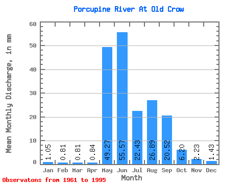
| Statistic | Jan | Feb | Mar | Apr | May | Jun | Jul | Aug | Sep | Oct | Nov | Dec | Annual |
|---|---|---|---|---|---|---|---|---|---|---|---|---|---|
| Mean | 1.05 | 0.82 | 0.81 | 0.84 | 49.27 | 55.57 | 22.43 | 26.89 | 20.52 | 6.20 | 2.23 | 1.43 | 183.67 |
| Standard Deviation | 0.21 | 0.17 | 0.13 | 0.24 | 27.71 | 22.29 | 12.60 | 15.04 | 9.22 | 2.48 | 0.69 | 0.33 | 47.35 |
| Min | 0.80 | 0.58 | 0.60 | 0.56 | 0.89 | 20.59 | 7.25 | 2.59 | 4.87 | 1.99 | 1.15 | 0.88 | 103.86 |
| Max | 1.64 | 1.25 | 1.17 | 1.93 | 103.45 | 115.56 | 51.72 | 52.69 | 42.90 | 11.26 | 4.25 | 2.34 | 285.74 |
| Coefficient of Variation | 0.20 | 0.20 | 0.16 | 0.29 | 0.56 | 0.40 | 0.56 | 0.56 | 0.45 | 0.40 | 0.31 | 0.23 | 0.26 |
| Other Close Sites | ||||||
|---|---|---|---|---|---|---|
| PointID | Latitude | Longitude | Drainage Area | Source | Name | |
| 5836 | "OLD CROW RIVER NEAR THE MOUTH" | 67.63 | 1884847 | Hydat | ||
 Return to R-Arctic Net Home Page