|
|
|||||||||||||||||
| Point ID: 5836 | Downloads | Plots | Site Data | Other Close Sites | Code: 09FC001 |
|
|
|||||||||||||||||
| Download | |
|---|---|
| Site Descriptor Information | Site Time Series Data |
| Link to all available data | |
| View: | Time Series | All |
| Units: | m3/s |
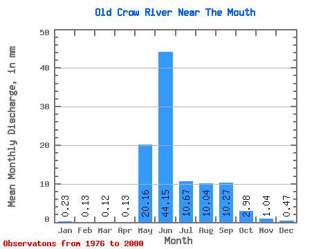
| Statistic | Jan | Feb | Mar | Apr | May | Jun | Jul | Aug | Sep | Oct | Nov | Dec | Annual |
|---|---|---|---|---|---|---|---|---|---|---|---|---|---|
| Mean | 0.23 | 0.13 | 0.12 | 0.13 | 20.16 | 44.15 | 10.67 | 10.04 | 10.27 | 2.98 | 1.04 | 0.47 | 102.76 |
| Standard Deviation | 0.16 | 0.10 | 0.08 | 0.07 | 16.27 | 25.29 | 5.44 | 9.09 | 8.32 | 2.34 | 0.96 | 0.37 | 45.58 |
| Min | 0.02 | 0.00 | 0.00 | 0.00 | 0.24 | 10.01 | 2.29 | 1.59 | 0.87 | 0.33 | 0.06 | 0.02 | 34.13 |
| Max | 0.76 | 0.38 | 0.25 | 0.23 | 54.33 | 118.22 | 18.55 | 31.79 | 31.14 | 10.04 | 4.34 | 1.60 | 170.01 |
| Coefficient of Variation | 0.70 | 0.73 | 0.64 | 0.49 | 0.81 | 0.57 | 0.51 | 0.91 | 0.81 | 0.79 | 0.92 | 0.79 | 0.44 |
| Other Close Sites | ||||||
|---|---|---|---|---|---|---|
| PointID | Latitude | Longitude | Drainage Area | Source | Name | |
| 5837 | "PORCUPINE RIVER AT OLD CROW" | 67.56 | 1895978 | Hydat | ||
 Return to R-Arctic Net Home Page