|
|
|||||||||||||||||
| Point ID: 5837 | Downloads | Plots | Site Data | Other Close Sites | Code: 09FD001 |
|
|
|||||||||||||||||
| Download | |
|---|---|
| Site Descriptor Information | Site Time Series Data |
| Link to all available data | |
| View: | Time Series | All |
| Units: | mm |
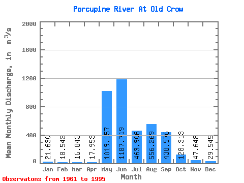
| Statistic | Jan | Feb | Mar | Apr | May | Jun | Jul | Aug | Sep | Oct | Nov | Dec | Annual |
|---|---|---|---|---|---|---|---|---|---|---|---|---|---|
| Mean | 21.63 | 18.54 | 16.84 | 17.95 | 1019.16 | 1187.72 | 463.91 | 556.27 | 438.58 | 128.31 | 47.65 | 29.55 | 322.42 |
| Standard Deviation | 4.27 | 3.79 | 2.76 | 5.17 | 573.35 | 476.33 | 260.60 | 311.25 | 197.10 | 51.20 | 14.82 | 6.76 | 83.12 |
| Min | 16.60 | 13.20 | 12.40 | 11.90 | 18.30 | 440.00 | 150.00 | 53.60 | 104.00 | 41.20 | 24.50 | 18.10 | 182.32 |
| Max | 34.00 | 28.30 | 24.10 | 41.20 | 2140.00 | 2470.00 | 1070.00 | 1090.00 | 917.00 | 233.00 | 90.90 | 48.50 | 501.57 |
| Coefficient of Variation | 0.20 | 0.20 | 0.16 | 0.29 | 0.56 | 0.40 | 0.56 | 0.56 | 0.45 | 0.40 | 0.31 | 0.23 | 0.26 |
| Other Close Sites | ||||||
|---|---|---|---|---|---|---|
| PointID | Latitude | Longitude | Drainage Area | Source | Name | |
| 5836 | "OLD CROW RIVER NEAR THE MOUTH" | 67.63 | 1884847 | Hydat | ||
 Return to R-Arctic Net Home Page