|
|
|||||||||||||||||
| Point ID: 5459 | Downloads | Plots | Site Data | Code: 05KH013 |
|
|
|||||||||||||||||
| Download | |
|---|---|
| Site Descriptor Information | Site Time Series Data |
| Link to all available data | |
| View: | Time Series | All |
| Units: | m3/s |
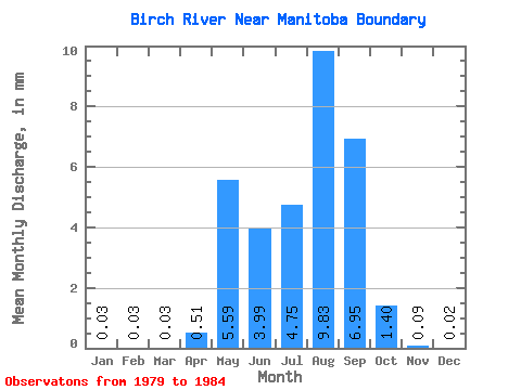
| Statistic | Jan | Feb | Mar | Apr | May | Jun | Jul | Aug | Sep | Oct | Nov | Dec | Annual |
|---|---|---|---|---|---|---|---|---|---|---|---|---|---|
| Mean | 0.03 | 0.03 | 0.03 | 0.52 | 5.59 | 4.00 | 4.75 | 9.83 | 6.95 | 1.40 | 0.09 | 0.02 | 26.47 |
| Standard Deviation | 0.00 | 0.00 | 0.00 | 0.97 | 5.20 | 3.17 | 3.47 | 5.91 | 7.30 | 1.62 | 0.12 | 0.01 | 9.18 |
| Min | 0.03 | 0.03 | 0.03 | 0.03 | 0.03 | 1.01 | 0.71 | 2.74 | 0.03 | 0.03 | 0.03 | 0.00 | 16.51 |
| Max | 0.03 | 0.03 | 0.03 | 1.97 | 13.11 | 8.22 | 9.17 | 19.05 | 20.70 | 3.72 | 0.26 | 0.03 | 37.80 |
| Coefficient of Variation | 0.00 | 0.00 | 0.00 | 1.89 | 0.93 | 0.79 | 0.73 | 0.60 | 1.05 | 1.16 | 1.34 | 0.67 | 0.35 |
 Return to R-Arctic Net Home Page