|
|
|||||||||||||||||
| Point ID: 5459 | Downloads | Plots | Site Data | Code: 05KH013 |
|
|
|||||||||||||||||
| Download | |
|---|---|
| Site Descriptor Information | Site Time Series Data |
| Link to all available data | |
| View: | Time Series | All |
| Units: | mm |
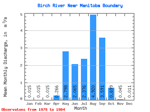
| Statistic | Jan | Feb | Mar | Apr | May | Jun | Jul | Aug | Sep | Oct | Nov | Dec | Annual |
|---|---|---|---|---|---|---|---|---|---|---|---|---|---|
| Mean | 0.01 | 0.01 | 0.01 | 0.27 | 2.80 | 2.06 | 2.38 | 4.92 | 3.59 | 0.70 | 0.04 | 0.01 | 1.12 |
| Standard Deviation | 0.00 | 0.00 | 0.00 | 0.50 | 2.60 | 1.64 | 1.73 | 2.96 | 3.77 | 0.81 | 0.06 | 0.01 | 0.39 |
| Min | 0.01 | 0.01 | 0.01 | 0.01 | 0.01 | 0.52 | 0.36 | 1.37 | 0.01 | 0.01 | 0.01 | 0.00 | 0.70 |
| Max | 0.01 | 0.01 | 0.01 | 1.02 | 6.56 | 4.25 | 4.59 | 9.53 | 10.70 | 1.86 | 0.14 | 0.01 | 1.60 |
| Coefficient of Variation | 0.00 | 0.00 | 0.00 | 1.89 | 0.93 | 0.79 | 0.73 | 0.60 | 1.05 | 1.16 | 1.34 | 0.67 | 0.35 |
 Return to R-Arctic Net Home Page