|
|
|||||||||||||||||
| Point ID: 106 | Downloads | Plots | Site Data | Code: 05AD030 |
|
|
|||||||||||||||||
| Download | |
|---|---|
| Site Descriptor Information | Site Time Series Data |
| Link to all available data | |
| View: | Time Series | All |
| Units: | m3/s |
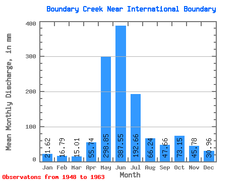
| Statistic | Jan | Feb | Mar | Apr | May | Jun | Jul | Aug | Sep | Oct | Nov | Dec | Annual |
|---|---|---|---|---|---|---|---|---|---|---|---|---|---|
| Mean | 21.61 | 16.92 | 15.01 | 55.74 | 298.80 | 387.57 | 192.62 | 66.22 | 47.66 | 73.14 | 45.79 | 30.97 | 1312.02 |
| Standard Deviation | 8.35 | 8.87 | 4.52 | 28.82 | 87.06 | 79.89 | 86.49 | 17.74 | 30.69 | 47.82 | 20.03 | 14.25 | 198.71 |
| Min | 11.78 | 9.10 | 7.70 | 18.47 | 135.64 | 247.18 | 96.89 | 46.90 | 28.28 | 17.54 | 10.87 | 10.68 | 973.69 |
| Max | 35.72 | 37.94 | 20.87 | 118.30 | 440.70 | 509.74 | 356.24 | 110.30 | 125.51 | 158.49 | 87.52 | 58.13 | 1548.09 |
| Coefficient of Variation | 0.39 | 0.52 | 0.30 | 0.52 | 0.29 | 0.21 | 0.45 | 0.27 | 0.64 | 0.65 | 0.44 | 0.46 | 0.15 |
 Return to R-Arctic Net Home Page