|
|
|||||||||||||||||
| Point ID: 106 | Downloads | Plots | Site Data | Code: 05AD030 |
|
|
|||||||||||||||||
| Download | |
|---|---|
| Site Descriptor Information | Site Time Series Data |
| Link to all available data | |
|
|
| View: | Statistics | Time Series |
| Units: | m3/s |
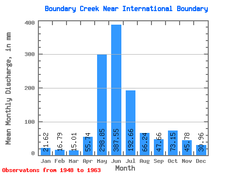
| Statistic | Jan | Feb | Mar | Apr | May | Jun | Jul | Aug | Sep | Oct | Nov | Dec | Annual |
|---|---|---|---|---|---|---|---|---|---|---|---|---|---|
| Mean | 21.61 | 16.92 | 15.01 | 55.74 | 298.80 | 387.57 | 192.62 | 66.22 | 47.66 | 73.14 | 45.79 | 30.97 | 1312.02 |
| Standard Deviation | 8.35 | 8.87 | 4.52 | 28.82 | 87.06 | 79.89 | 86.49 | 17.74 | 30.69 | 47.82 | 20.03 | 14.25 | 198.71 |
| Min | 11.78 | 9.10 | 7.70 | 18.47 | 135.64 | 247.18 | 96.89 | 46.90 | 28.28 | 17.54 | 10.87 | 10.68 | 973.69 |
| Max | 35.72 | 37.94 | 20.87 | 118.30 | 440.70 | 509.74 | 356.24 | 110.30 | 125.51 | 158.49 | 87.52 | 58.13 | 1548.09 |
| Coefficient of Variation | 0.39 | 0.52 | 0.30 | 0.52 | 0.29 | 0.21 | 0.45 | 0.27 | 0.64 | 0.65 | 0.44 | 0.46 | 0.15 |
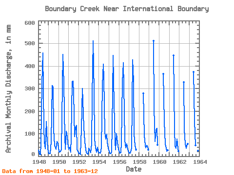
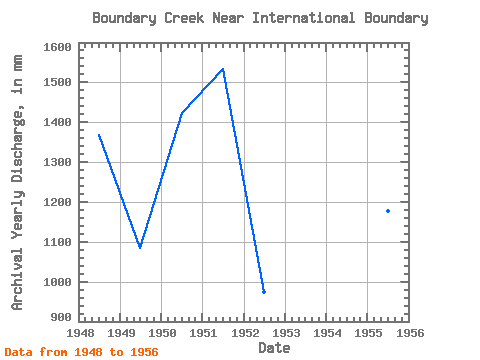
| Year | Jan | Feb | Mar | Apr | May | Jun | Jul | Aug | Sep | Oct | Nov | Dec | Annual | 1948 | 27.57 | 9.10 | 7.70 | 54.34 | 330.90 | 457.81 | 130.67 | 65.09 | 34.34 | 158.49 | 63.48 | 33.94 | 1369.55 | 1949 | 11.78 | 10.28 | 12.92 | 63.00 | 323.94 | 304.88 | 121.73 | 49.39 | 37.46 | 31.40 | 64.92 | 57.14 | 1085.62 | 1950 | 20.17 | 18.20 | 20.87 | 31.79 | 176.38 | 451.56 | 331.89 | 85.46 | 32.03 | 113.78 | 87.52 | 58.13 | 1423.57 | 1951 | 32.79 | 37.94 | 19.87 | 84.16 | 341.33 | 332.78 | 285.19 | 89.43 | 125.51 | 140.11 | 31.55 | 20.67 | 1536.04 | 1952 | 12.12 | 12.31 | 8.50 | 118.30 | 310.53 | 247.18 | 130.17 | 68.56 | 30.01 | 17.54 | 10.87 | 10.68 | 973.69 | 1953 | 35.72 | 26.39 | 16.74 | 55.30 | 269.29 | 509.74 | 297.11 | 78.00 | 37.65 | 18.58 | 40.35 | 26.58 | 1409.66 | 1954 | 15.55 | 16.02 | 15.55 | 36.64 | 322.95 | 406.83 | 356.24 | 110.30 | 76.46 | 100.86 | 62.03 | 36.02 | 1548.09 | 1955 | 22.80 | 13.08 | 12.87 | 18.47 | 135.64 | 445.79 | 241.96 | 64.59 | 28.85 | 102.85 | 60.59 | 31.30 | 1176.96 | 1956 | 22.36 | 12.18 | 15.85 | 58.67 | 336.37 | 414.05 | 206.19 | 72.04 | 36.60 | 57.63 | 31.21 | 26.23 | 1285.04 | 1957 | 15.25 | 13.72 | 19.18 | 36.74 | 440.70 | 331.33 | 100.36 | 46.90 | 28.28 | 1958 | 277.47 | 96.89 | 50.18 | 38.28 | 49.54 | 41.45 | 29.21 | 1959 | 509.74 | 223.08 | 67.57 | 116.38 | 127.19 | 51.45 | 1960 | 365.00 | 159.49 | 56.64 | 35.92 | 22.86 | 27.46 | 1961 | 445.79 | 118.75 | 48.79 | 36.55 | 78.50 | 33.28 | 23.20 | 1962 | 328.93 | 122.22 | 57.63 | 36.16 | 54.65 | 55.30 | 1963 | 372.21 | 159.98 | 48.89 | 32.12 | 23.05 | 25.44 | 18.58 |
|---|
 Return to R-Arctic Net Home Page