|
|
|||||||||||||||||
| Point ID: 106 | Downloads | Plots | Site Data | Code: 05AD030 |
|
|
|||||||||||||||||
| Download | |
|---|---|
| Site Descriptor Information | Site Time Series Data |
| Link to all available data | |
| View: | Time Series | All |
| Units: | mm |
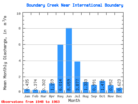
| Statistic | Jan | Feb | Mar | Apr | May | Jun | Jul | Aug | Sep | Oct | Nov | Dec | Annual |
|---|---|---|---|---|---|---|---|---|---|---|---|---|---|
| Mean | 0.43 | 0.37 | 0.30 | 1.16 | 6.01 | 8.06 | 3.88 | 1.33 | 0.99 | 1.47 | 0.95 | 0.62 | 2.24 |
| Standard Deviation | 0.17 | 0.20 | 0.09 | 0.60 | 1.75 | 1.66 | 1.74 | 0.36 | 0.64 | 0.96 | 0.42 | 0.29 | 0.34 |
| Min | 0.24 | 0.20 | 0.15 | 0.38 | 2.73 | 5.14 | 1.95 | 0.94 | 0.59 | 0.35 | 0.23 | 0.21 | 1.66 |
| Max | 0.72 | 0.84 | 0.42 | 2.46 | 8.87 | 10.60 | 7.17 | 2.22 | 2.61 | 3.19 | 1.82 | 1.17 | 2.64 |
| Coefficient of Variation | 0.39 | 0.52 | 0.30 | 0.52 | 0.29 | 0.21 | 0.45 | 0.27 | 0.64 | 0.65 | 0.44 | 0.46 | 0.15 |
 Return to R-Arctic Net Home Page