|
|
| Point ID: 7748 | Downloads | Plots | Site Data | Code: 05AB040 |
|
| Download | |
|---|---|
| Site Descriptor Information | Site Time Series Data |
| Link to all available data | |
|
|
|
| View: | Statistics | All |
| Units: | mm |
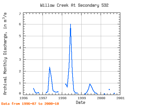
| Year | Jan | Feb | Mar | Apr | May | Jun | Jul | Aug | Sep | Oct | Nov | Dec | Annual | 1996 | 0.54 | 0.19 | 0.14 | 0.17 | 1997 | 0.19 | 0.27 | 2.35 | 1.42 | 0.35 | 0.24 | 0.21 | 0.23 | 1998 | 0.89 | 0.63 | 2.37 | 6.01 | 1.98 | 0.34 | 0.14 | 0.13 | 1999 | 0.07 | 0.18 | 0.47 | 0.92 | 0.67 | 0.37 | 0.16 | 0.11 | 2000 | 0.07 | 0.44 | 0.21 | 0.07 | 0.11 | 0.09 |
|---|
 Return to R-Arctic Net Home Page