|
|
| Point ID: 7748 | Downloads | Plots | Site Data | Code: 05AB040 |
|
| Download | |
|---|---|
| Site Descriptor Information | Site Time Series Data |
| Link to all available data | |
|
|
|
| View: | Statistics | All |
| Units: | m3/s |
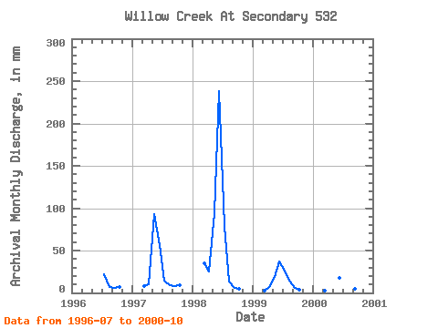
| Year | Jan | Feb | Mar | Apr | May | Jun | Jul | Aug | Sep | Oct | Nov | Dec | Annual | 1996 | 22.31 | 7.67 | 5.76 | 6.77 | 1997 | 7.92 | 10.56 | 96.38 | 56.37 | 14.48 | 9.72 | 8.49 | 9.43 | 1998 | 36.62 | 24.93 | 97.19 | 238.56 | 81.20 | 14.11 | 5.52 | 5.17 | 1999 | 2.83 | 7.03 | 19.23 | 36.68 | 27.39 | 15.01 | 6.43 | 4.39 | 2000 | 2.67 | 17.31 | 8.73 | 2.99 | 4.53 | 3.65 |
|---|
 Return to R-Arctic Net Home Page