|
|
|||||||||||||||||
| Point ID: 7748 | Downloads | Plots | Site Data | Code: 05AB040 |
|
|
|||||||||||||||||
| Download | |
|---|---|
| Site Descriptor Information | Site Time Series Data |
| Link to all available data | |
| View: | Time Series | All |
| Units: | mm |
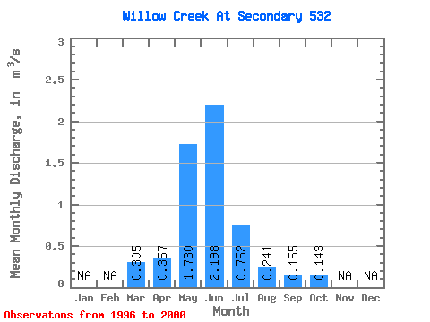
| Statistic | Jan | Feb | Mar | Apr | May | Jun | Jul | Aug | Sep | Oct | Nov | Dec | Annual |
|---|---|---|---|---|---|---|---|---|---|---|---|---|---|
| Mean | 0.30 | 0.36 | 1.73 | 2.20 | 0.75 | 0.24 | 0.15 | 0.14 | |||||
| Standard Deviation | 0.40 | 0.24 | 1.09 | 2.57 | 0.71 | 0.12 | 0.04 | 0.06 | |||||
| Min | 0.07 | 0.18 | 0.47 | 0.44 | 0.21 | 0.07 | 0.11 | 0.09 | |||||
| Max | 0.89 | 0.63 | 2.37 | 6.01 | 1.98 | 0.37 | 0.21 | 0.23 | |||||
| Coefficient of Variation | 1.30 | 0.67 | 0.63 | 1.17 | 0.94 | 0.50 | 0.24 | 0.39 |
 Return to R-Arctic Net Home Page