|
|
| Point ID: 5410 | Downloads | Plots | Site Data | Code: 05JM008 |
|
| Download | |
|---|---|
| Site Descriptor Information | Site Time Series Data |
| Link to all available data | |
|
|
|
| View: | Statistics | All |
| Units: | m3/s |
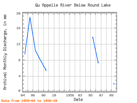
| Year | Jan | Feb | Mar | Apr | May | Jun | Jul | Aug | Sep | Oct | Nov | Dec | Annual | 1955 | 3.13 | 6.37 | 3.41 | 2.69 | 1.86 | 1956 | 4.64 | 2.42 | 1.64 | 1.10 | 0.68 | 0.37 |
|---|
 Return to R-Arctic Net Home Page