|
|
| Point ID: 5410 | Downloads | Plots | Site Data | Code: 05JM008 |
|
| Download | |
|---|---|
| Site Descriptor Information | Site Time Series Data |
| Link to all available data | |
|
|
|
| View: | Statistics | All |
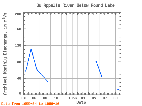
| Units: | mm |
| Year | Jan | Feb | Mar | Apr | May | Jun | Jul | Aug | Sep | Oct | Nov | Dec | Annual | 1955 | 56.90 | 112.00 | 62.00 | 47.30 | 32.70 | 1956 | 81.70 | 43.90 | 28.80 | 19.40 | 12.40 | 6.53 |
|---|
 Return to R-Arctic Net Home Page