|
|
|||||||||||||||||
| Point ID: 5410 | Downloads | Plots | Site Data | Code: 05JM008 |
|
|
|||||||||||||||||
| Download | |
|---|---|
| Site Descriptor Information | Site Time Series Data |
| Link to all available data | |
| View: | Time Series | All |
| Units: | m3/s |
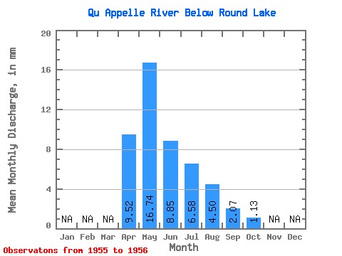
| Statistic | Jan | Feb | Mar | Apr | May | Jun | Jul | Aug | Sep | Oct | Nov | Dec | Annual |
|---|---|---|---|---|---|---|---|---|---|---|---|---|---|
| Mean | 3.13 | 5.51 | 2.91 | 2.16 | 1.48 | 0.68 | 0.37 | ||||||
| Standard Deviation | 1.22 | 0.70 | 0.74 | 0.54 | |||||||||
| Min | 3.13 | 4.64 | 2.42 | 1.64 | 1.10 | 0.68 | 0.37 | ||||||
| Max | 3.13 | 6.37 | 3.41 | 2.69 | 1.86 | 0.68 | 0.37 | ||||||
| Coefficient of Variation | 0.22 | 0.24 | 0.34 | 0.36 |
 Return to R-Arctic Net Home Page