|
|
| Point ID: 281 | Downloads | Plots | Site Data | Code: 05BH002 |
|
| Download | |
|---|---|
| Site Descriptor Information | Site Time Series Data |
| Link to all available data | |
|
|
|
| View: | Statistics | All |
| Units: | m3/s |
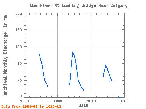
| Year | Jan | Feb | Mar | Apr | May | Jun | Jul | Aug | Sep | Oct | Nov | Dec | Annual | 1908 | 99.32 | 79.55 | 40.83 | 26.18 | 1909 | 30.49 | 104.96 | 90.95 | 41.89 | 25.23 | 17.84 | 1910 | 50.11 | 75.71 | 59.66 | 39.77 | 25.02 | 23.23 | 9.04 |
|---|
 Return to R-Arctic Net Home Page