|
|
|||||||||||||||||
| Point ID: 281 | Downloads | Plots | Site Data | Code: 05BH002 |
|
|
|||||||||||||||||
| Download | |
|---|---|
| Site Descriptor Information | Site Time Series Data |
| Link to all available data | |
| View: | Time Series | All |
| Units: | m3/s |
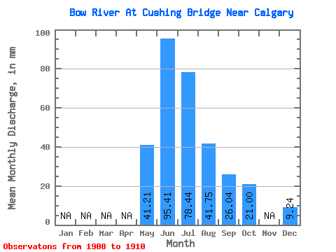
| Statistic | Jan | Feb | Mar | Apr | May | Jun | Jul | Aug | Sep | Oct | Nov | Dec | Annual |
|---|---|---|---|---|---|---|---|---|---|---|---|---|---|
| Mean | 40.30 | 93.33 | 76.72 | 40.83 | 25.48 | 20.54 | 9.04 | ||||||
| Standard Deviation | 13.87 | 15.52 | 15.83 | 1.06 | 0.62 | 3.81 | |||||||
| Min | 30.49 | 75.71 | 59.66 | 39.77 | 25.02 | 17.84 | 9.04 | ||||||
| Max | 50.11 | 104.96 | 90.95 | 41.89 | 26.18 | 23.23 | 9.04 | ||||||
| Coefficient of Variation | 0.34 | 0.17 | 0.21 | 0.03 | 0.02 | 0.18 |
 Return to R-Arctic Net Home Page