|
|
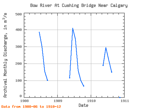
| Point ID: 281 | Downloads | Plots | Site Data | Code: 05BH002 |
|
| Download | |
|---|---|
| Site Descriptor Information | Site Time Series Data |
| Link to all available data | |
|
|
|
| View: | Statistics | All |
| Units: | mm |
| Year | Jan | Feb | Mar | Apr | May | Jun | Jul | Aug | Sep | Oct | Nov | Dec | Annual | 1908 | 387.00 | 300.00 | 154.00 | 102.00 | 1909 | 115.00 | 409.00 | 343.00 | 158.00 | 98.30 | 67.30 | 1910 | 189.00 | 295.00 | 225.00 | 150.00 | 97.50 | 87.60 | 34.10 |
|---|
 Return to R-Arctic Net Home Page