|
|
|||||||||||||||||
| Point ID: 9426 | Downloads | Plots | Site Data | Code: 15564879 |
|
|
|||||||||||||||||
| Download | |
|---|---|
| Site Descriptor Information | Site Time Series Data |
| Link to all available data | |
|
|
| View: | Statistics | Time Series |
| Units: | mm |
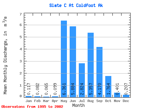
| Statistic | Jan | Feb | Mar | Apr | May | Jun | Jul | Aug | Sep | Oct | Nov | Dec | Annual |
|---|---|---|---|---|---|---|---|---|---|---|---|---|---|
| Mean | 0.12 | 0.08 | 0.07 | 0.10 | 6.36 | 5.88 | 2.82 | 5.36 | 4.17 | 1.76 | 0.40 | 0.21 | 2.01 |
| Standard Deviation | 0.16 | 0.12 | 0.10 | 0.11 | 2.92 | 1.81 | 1.28 | 3.25 | 1.56 | 1.43 | 0.33 | 0.21 | 0.21 |
| Min | 0.00 | 0.00 | 0.00 | 0.00 | 2.03 | 3.64 | 1.55 | 1.49 | 2.03 | 0.46 | 0.06 | 0.04 | 1.80 |
| Max | 0.34 | 0.26 | 0.20 | 0.26 | 10.72 | 8.73 | 5.22 | 12.33 | 6.00 | 4.68 | 0.85 | 0.49 | 2.23 |
| Coefficient of Variation | 1.37 | 1.48 | 1.46 | 1.15 | 0.46 | 0.31 | 0.45 | 0.61 | 0.38 | 0.81 | 0.81 | 1.03 | 0.11 |
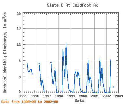
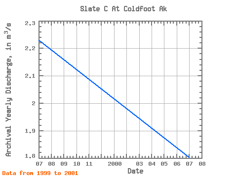
| Year | Jan | Feb | Mar | Apr | May | Jun | Jul | Aug | Sep | Oct | Nov | Dec | Annual | 1995 | 7.25 | 5.25 | 5.22 | 5.76 | 5.78 | 4.68 | 1996 | 7.38 | 4.22 | 1.55 | 3.43 | 2.03 | 0.46 | 1997 | 7.46 | 3.64 | 1.89 | 3.63 | 5.96 | 1.03 | 0.06 | 1998 | 0.26 | 10.72 | 6.26 | 3.57 | 12.33 | 6.00 | 2.51 | 0.85 | 0.49 | 1999 | 0.34 | 0.26 | 0.20 | 0.16 | 5.38 | 4.79 | 3.86 | 5.44 | 4.09 | 1.35 | 0.62 | 0.25 | 2.23 | 2000 | 0.11 | 0.07 | 0.06 | 0.07 | 2.03 | 8.20 | 2.18 | 4.01 | 3.48 | 1.08 | 0.29 | 0.05 | 1.80 | 2001 | 0.00 | 0.00 | 0.00 | 0.00 | 2.52 | 8.73 | 1.83 | 6.76 | 2.70 | 1.23 | 0.18 | 0.04 | 2.00 | 2002 | 0.01 | 0.00 | 0.00 | 0.00 | 8.15 | 5.98 | 2.49 | 1.49 | 3.32 |
|---|
 Return to R-Arctic Net Home Page