|
|
|||||||||||||||||
| Point ID: 9426 | Downloads | Plots | Site Data | Code: 15564879 |
|
|
|||||||||||||||||
| Download | |
|---|---|
| Site Descriptor Information | Site Time Series Data |
| Link to all available data | |
| View: | Time Series | All |
| Units: | mm |
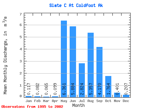
| Statistic | Jan | Feb | Mar | Apr | May | Jun | Jul | Aug | Sep | Oct | Nov | Dec | Annual |
|---|---|---|---|---|---|---|---|---|---|---|---|---|---|
| Mean | 0.12 | 0.08 | 0.07 | 0.10 | 6.36 | 5.88 | 2.82 | 5.36 | 4.17 | 1.76 | 0.40 | 0.21 | 2.01 |
| Standard Deviation | 0.16 | 0.12 | 0.10 | 0.11 | 2.92 | 1.81 | 1.28 | 3.25 | 1.56 | 1.43 | 0.33 | 0.21 | 0.21 |
| Min | 0.00 | 0.00 | 0.00 | 0.00 | 2.03 | 3.64 | 1.55 | 1.49 | 2.03 | 0.46 | 0.06 | 0.04 | 1.80 |
| Max | 0.34 | 0.26 | 0.20 | 0.26 | 10.72 | 8.73 | 5.22 | 12.33 | 6.00 | 4.68 | 0.85 | 0.49 | 2.23 |
| Coefficient of Variation | 1.37 | 1.48 | 1.46 | 1.15 | 0.46 | 0.31 | 0.45 | 0.61 | 0.38 | 0.81 | 0.81 | 1.03 | 0.11 |
 Return to R-Arctic Net Home Page