|
|
|||||||||||||||||
| Point ID: 9426 | Downloads | Plots | Site Data | Code: 15564879 |
|
|
|||||||||||||||||
| Download | |
|---|---|
| Site Descriptor Information | Site Time Series Data |
| Link to all available data | |
|
|
| View: | Statistics | Time Series |
| Units: | m3/s |
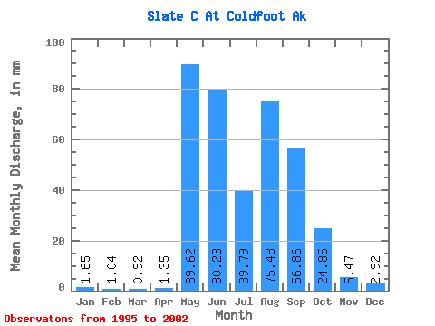
| Statistic | Jan | Feb | Mar | Apr | May | Jun | Jul | Aug | Sep | Oct | Nov | Dec | Annual |
|---|---|---|---|---|---|---|---|---|---|---|---|---|---|
| Mean | 1.64 | 1.05 | 0.92 | 1.34 | 89.61 | 80.22 | 39.79 | 75.47 | 56.86 | 24.85 | 5.47 | 2.91 | 333.66 |
| Standard Deviation | 2.25 | 1.56 | 1.34 | 1.54 | 41.12 | 24.72 | 17.98 | 45.84 | 21.33 | 20.11 | 4.45 | 3.00 | 35.47 |
| Min | 0.05 | 0.00 | 0.00 | 0.00 | 28.60 | 49.59 | 21.84 | 21.05 | 27.67 | 6.48 | 0.88 | 0.56 | 299.15 |
| Max | 4.84 | 3.30 | 2.84 | 3.60 | 150.98 | 119.01 | 73.58 | 173.67 | 81.88 | 65.98 | 11.57 | 6.91 | 370.02 |
| Coefficient of Variation | 1.37 | 1.48 | 1.46 | 1.15 | 0.46 | 0.31 | 0.45 | 0.61 | 0.38 | 0.81 | 0.81 | 1.03 | 0.11 |
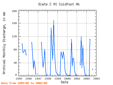
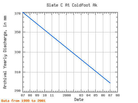
| Year | Jan | Feb | Mar | Apr | May | Jun | Jul | Aug | Sep | Oct | Nov | Dec | Annual | 1995 | 102.13 | 71.63 | 73.58 | 81.17 | 78.84 | 65.98 | 1996 | 103.92 | 57.52 | 21.84 | 48.37 | 27.67 | 6.48 | 1997 | 105.13 | 49.59 | 26.62 | 51.14 | 81.26 | 14.56 | 0.88 | 1998 | 3.60 | 150.98 | 85.42 | 50.35 | 173.67 | 81.88 | 35.31 | 11.57 | 6.91 | 1999 | 4.84 | 3.30 | 2.84 | 2.17 | 75.81 | 65.30 | 54.35 | 76.66 | 55.73 | 19.06 | 8.52 | 3.52 | 370.02 | 2000 | 1.60 | 0.90 | 0.84 | 0.94 | 28.60 | 111.73 | 30.70 | 56.52 | 47.39 | 15.29 | 3.92 | 0.66 | 299.15 | 2001 | 0.05 | 0.00 | 0.00 | 0.00 | 35.53 | 119.01 | 25.74 | 95.17 | 36.78 | 17.31 | 2.46 | 0.56 | 331.80 | 2002 | 0.08 | 0.00 | 0.00 | 0.01 | 114.75 | 81.60 | 35.13 | 21.05 | 45.33 |
|---|
 Return to R-Arctic Net Home Page