|
|
|||||||||||||||||
| Point ID: 9378 | Downloads | Plots | Site Data | Code: 15300000 |
|
|
|||||||||||||||||
| Download | |
|---|---|
| Site Descriptor Information | Site Time Series Data |
| Link to all available data | |
|
|
| View: | Statistics | Time Series |
| Units: | mm |
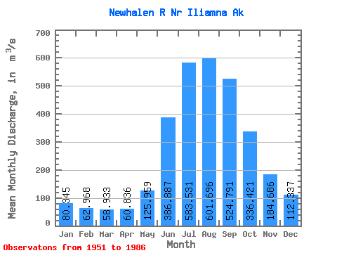
| Statistic | Jan | Feb | Mar | Apr | May | Jun | Jul | Aug | Sep | Oct | Nov | Dec | Annual |
|---|---|---|---|---|---|---|---|---|---|---|---|---|---|
| Mean | 80.34 | 62.97 | 58.93 | 60.84 | 125.96 | 386.89 | 583.53 | 601.70 | 524.79 | 336.42 | 184.69 | 112.34 | 258.34 |
| Standard Deviation | 24.31 | 18.88 | 16.82 | 18.67 | 33.62 | 86.26 | 89.20 | 89.62 | 112.58 | 99.29 | 56.49 | 36.73 | 26.97 |
| Min | 33.98 | 28.32 | 28.32 | 33.98 | 69.33 | 230.19 | 454.35 | 449.60 | 271.43 | 202.36 | 96.28 | 50.97 | 219.71 |
| Max | 130.07 | 99.89 | 94.34 | 92.63 | 180.56 | 559.35 | 734.59 | 846.03 | 720.19 | 563.60 | 308.72 | 181.43 | 307.90 |
| Coefficient of Variation | 0.30 | 0.30 | 0.28 | 0.31 | 0.27 | 0.22 | 0.15 | 0.15 | 0.21 | 0.29 | 0.31 | 0.33 | 0.10 |
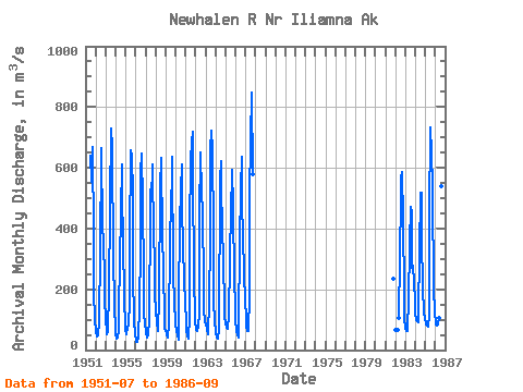
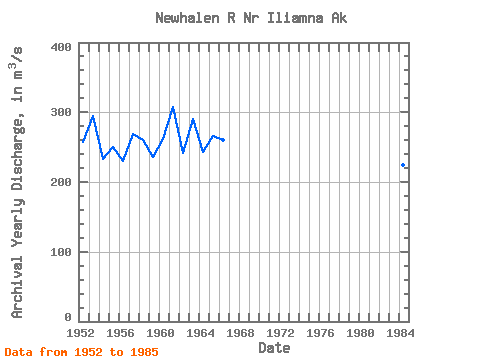
| Year | Jan | Feb | Mar | Apr | May | Jun | Jul | Aug | Sep | Oct | Nov | Dec | Annual | 1951 | 638.32 | 554.37 | 666.86 | 369.47 | 188.08 | 101.58 | 1952 | 63.48 | 43.94 | 46.77 | 55.22 | 88.27 | 331.68 | 643.34 | 665.36 | 394.36 | 370.22 | 220.72 | 158.21 | 256.80 | 1953 | 108.24 | 53.60 | 60.93 | 77.87 | 180.56 | 480.35 | 730.30 | 666.45 | 641.57 | 328.80 | 131.74 | 79.29 | 294.98 | 1954 | 50.97 | 36.81 | 42.48 | 67.96 | 130.26 | 286.98 | 454.35 | 609.45 | 531.41 | 340.85 | 186.92 | 63.39 | 233.49 | 1955 | 63.85 | 50.77 | 75.08 | 84.95 | 154.13 | 358.77 | 658.41 | 637.40 | 514.23 | 256.44 | 96.28 | 50.97 | 250.11 | 1956 | 33.98 | 28.32 | 28.32 | 39.64 | 140.85 | 337.39 | 583.05 | 646.90 | 481.76 | 245.61 | 111.85 | 89.97 | 230.64 | 1957 | 56.54 | 43.99 | 39.64 | 49.55 | 101.48 | 454.30 | 529.07 | 488.24 | 612.87 | 359.55 | 308.72 | 181.43 | 268.78 | 1958 | 130.07 | 86.87 | 67.87 | 63.23 | 169.34 | 534.60 | 633.75 | 609.54 | 389.55 | 257.76 | 116.71 | 70.79 | 260.84 | 1959 | 65.13 | 50.97 | 39.64 | 39.64 | 84.32 | 351.90 | 493.08 | 558.39 | 635.62 | 259.74 | 148.76 | 100.20 | 235.62 | 1960 | 84.86 | 63.86 | 52.34 | 33.98 | 155.09 | 421.83 | 524.23 | 610.91 | 470.72 | 337.70 | 232.20 | 155.74 | 261.95 | 1961 | 93.45 | 67.96 | 48.14 | 36.81 | 107.88 | 400.00 | 622.97 | 686.27 | 720.19 | 563.60 | 250.60 | 96.92 | 307.90 | 1962 | 66.50 | 66.44 | 62.30 | 77.33 | 124.14 | 437.97 | 649.10 | 515.55 | 459.11 | 213.94 | 133.64 | 93.45 | 241.62 | 1963 | 79.29 | 76.45 | 67.96 | 50.97 | 164.24 | 361.80 | 662.80 | 723.91 | 660.44 | 382.82 | 163.29 | 94.72 | 290.73 | 1964 | 59.28 | 42.57 | 39.55 | 36.81 | 69.33 | 559.35 | 621.78 | 499.84 | 433.72 | 265.02 | 171.32 | 112.90 | 242.62 | 1965 | 87.78 | 73.62 | 70.79 | 73.62 | 108.52 | 297.42 | 472.98 | 566.43 | 592.39 | 471.80 | 232.20 | 144.42 | 266.00 | 1966 | 93.45 | 65.13 | 48.14 | 42.48 | 79.62 | 353.84 | 528.06 | 635.03 | 478.84 | 379.17 | 252.49 | 162.69 | 259.91 | 1967 | 108.52 | 77.67 | 61.57 | 61.54 | 177.94 | 503.66 | 693.58 | 846.03 | 580.12 | 1981 | 233.90 | 1982 | 65.69 | 67.11 | 105.39 | 309.35 | 501.67 | 563.32 | 586.06 | 428.59 | 189.34 | 108.79 | 1983 | 70.06 | 62.70 | 62.30 | 73.21 | 158.38 | 350.27 | 472.16 | 449.60 | 271.43 | 278.67 | 225.59 | 162.14 | 219.71 | 1984 | 122.31 | 99.89 | 94.34 | 92.63 | 123.04 | 321.71 | 516.37 | 517.19 | 367.45 | 202.36 | 127.61 | 100.84 | 223.81 | 1985 | 90.52 | 83.13 | 80.20 | 76.67 | 114.86 | 441.26 | 734.59 | 648.73 | 542.74 | 518.84 | 205.66 | 118.29 | 304.62 | 1986 | 93.26 | 84.65 | 82.12 | 82.59 | 107.51 | 230.19 | 473.71 | 538.39 | 513.95 |
|---|
 Return to R-Arctic Net Home Page