|
|
|||||||||||||||||
| Point ID: 9219 | Downloads | Plots | Site Data | Code: 15208000 |
|
|
|||||||||||||||||
| Download | |
|---|---|
| Site Descriptor Information | Site Time Series Data |
| Link to all available data | |
| View: | Time Series | All |
| Units: | m3/s |
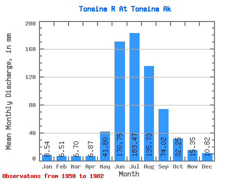
| Statistic | Jan | Feb | Mar | Apr | May | Jun | Jul | Aug | Sep | Oct | Nov | Dec | Annual |
|---|---|---|---|---|---|---|---|---|---|---|---|---|---|
| Mean | 8.54 | 6.56 | 6.70 | 6.87 | 41.79 | 170.75 | 183.44 | 135.72 | 74.02 | 32.24 | 15.35 | 10.82 | 692.68 |
| Standard Deviation | 2.51 | 2.00 | 1.95 | 1.99 | 21.23 | 60.60 | 38.98 | 26.57 | 34.31 | 13.03 | 5.93 | 3.67 | 129.66 |
| Min | 3.83 | 2.71 | 2.55 | 2.62 | 17.16 | 84.30 | 109.49 | 70.86 | 32.57 | 17.62 | 7.65 | 5.39 | 423.30 |
| Max | 15.04 | 13.84 | 13.27 | 11.63 | 99.21 | 316.09 | 285.06 | 205.63 | 191.35 | 73.70 | 32.41 | 20.91 | 955.49 |
| Coefficient of Variation | 0.29 | 0.30 | 0.29 | 0.29 | 0.51 | 0.35 | 0.21 | 0.20 | 0.46 | 0.40 | 0.39 | 0.34 | 0.19 |
 Return to R-Arctic Net Home Page