|
|
|||||||||||||||||
| Point ID: 9219 | Downloads | Plots | Site Data | Code: 15208000 |
|
|
|||||||||||||||||
| Download | |
|---|---|
| Site Descriptor Information | Site Time Series Data |
| Link to all available data | |
|
|
| View: | Statistics | Time Series |
| Units: | m3/s |
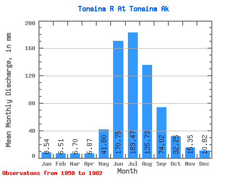
| Statistic | Jan | Feb | Mar | Apr | May | Jun | Jul | Aug | Sep | Oct | Nov | Dec | Annual |
|---|---|---|---|---|---|---|---|---|---|---|---|---|---|
| Mean | 8.54 | 6.56 | 6.70 | 6.87 | 41.79 | 170.75 | 183.44 | 135.72 | 74.02 | 32.24 | 15.35 | 10.82 | 692.68 |
| Standard Deviation | 2.51 | 2.00 | 1.95 | 1.99 | 21.23 | 60.60 | 38.98 | 26.57 | 34.31 | 13.03 | 5.93 | 3.67 | 129.66 |
| Min | 3.83 | 2.71 | 2.55 | 2.62 | 17.16 | 84.30 | 109.49 | 70.86 | 32.57 | 17.62 | 7.65 | 5.39 | 423.30 |
| Max | 15.04 | 13.84 | 13.27 | 11.63 | 99.21 | 316.09 | 285.06 | 205.63 | 191.35 | 73.70 | 32.41 | 20.91 | 955.49 |
| Coefficient of Variation | 0.29 | 0.30 | 0.29 | 0.29 | 0.51 | 0.35 | 0.21 | 0.20 | 0.46 | 0.40 | 0.39 | 0.34 | 0.19 |
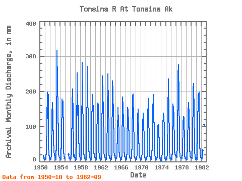
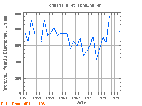
| Year | Jan | Feb | Mar | Apr | May | Jun | Jul | Aug | Sep | Oct | Nov | Dec | Annual | 1950 | 18.75 | 7.65 | 7.31 | 1951 | 6.61 | 5.55 | 6.11 | 6.07 | 33.35 | 111.20 | 204.88 | 126.20 | 191.35 | 44.24 | 22.94 | 10.46 | 766.51 | 1952 | 6.97 | 5.72 | 5.93 | 5.74 | 18.38 | 132.10 | 173.94 | 129.46 | 52.69 | 66.59 | 27.27 | 20.91 | 641.77 | 1953 | 11.85 | 7.62 | 4.88 | 5.91 | 58.66 | 316.09 | 233.26 | 148.71 | 74.23 | 24.87 | 13.49 | 11.15 | 908.49 | 1954 | 9.06 | 6.99 | 6.48 | 5.53 | 71.50 | 178.13 | 161.08 | 179.18 | 77.96 | 26.07 | 19.54 | 9.76 | 747.65 | 1955 | 21.30 | 8.77 | 7.67 | 1956 | 6.97 | 6.35 | 7.67 | 9.45 | 29.16 | 159.71 | 214.06 | 128.34 | 45.52 | 17.62 | 10.64 | 19.72 | 651.41 | 1957 | 6.83 | 3.90 | 7.26 | 8.77 | 68.67 | 252.80 | 136.50 | 145.00 | 160.36 | 73.70 | 32.41 | 13.88 | 908.94 | 1958 | 12.17 | 7.33 | 7.31 | 5.87 | 34.87 | 283.79 | 180.80 | 97.88 | 41.41 | 25.50 | 13.56 | 8.01 | 717.55 | 1959 | 5.62 | 4.65 | 5.10 | 4.32 | 39.52 | 272.01 | 175.81 | 140.48 | 41.65 | 38.89 | 18.22 | 12.53 | 756.58 | 1960 | 8.34 | 5.72 | 6.16 | 5.46 | 97.25 | 191.53 | 185.07 | 146.82 | 112.88 | 33.85 | 14.17 | 13.22 | 816.89 | 1961 | 12.23 | 7.67 | 6.33 | 5.37 | 55.37 | 159.55 | 173.22 | 166.39 | 79.36 | 34.28 | 14.17 | 8.37 | 718.51 | 1962 | 6.20 | 5.27 | 5.51 | 5.94 | 30.07 | 244.32 | 196.27 | 154.87 | 48.70 | 29.30 | 14.17 | 10.46 | 748.33 | 1963 | 8.37 | 6.35 | 6.90 | 6.68 | 43.12 | 119.72 | 259.15 | 160.94 | 92.95 | 25.10 | 10.80 | 9.76 | 744.51 | 1964 | 9.06 | 6.99 | 6.97 | 8.77 | 25.00 | 229.81 | 205.85 | 133.87 | 58.52 | 28.64 | 21.50 | 14.25 | 746.86 | 1965 | 8.93 | 7.62 | 8.37 | 8.10 | 17.93 | 84.30 | 159.80 | 114.83 | 85.98 | 35.56 | 15.52 | 10.46 | 554.45 | 1966 | 7.67 | 6.35 | 6.69 | 6.07 | 21.18 | 184.56 | 160.50 | 115.54 | 83.76 | 34.63 | 17.54 | 11.15 | 654.01 | 1967 | 8.37 | 6.03 | 5.58 | 5.12 | 35.98 | 154.76 | 150.91 | 111.13 | 69.51 | 25.03 | 12.22 | 9.49 | 591.94 | 1968 | 9.06 | 8.70 | 10.84 | 8.66 | 61.97 | 187.53 | 199.09 | 118.62 | 53.58 | 19.08 | 11.29 | 10.14 | 695.38 | 1969 | 8.88 | 6.69 | 6.08 | 6.91 | 26.32 | 126.22 | 154.45 | 70.86 | 35.29 | 19.91 | 10.91 | 8.23 | 478.62 | 1970 | 6.72 | 5.49 | 5.82 | 7.36 | 30.72 | 105.23 | 143.56 | 125.53 | 52.68 | 22.25 | 12.14 | 8.07 | 522.46 | 1971 | 6.67 | 5.19 | 5.05 | 5.84 | 21.91 | 121.30 | 186.49 | 143.88 | 50.42 | 28.49 | 15.92 | 11.69 | 598.85 | 1972 | 9.62 | 6.90 | 6.61 | 6.41 | 57.70 | 138.61 | 197.73 | 147.97 | 79.54 | 40.89 | 21.09 | 10.97 | 719.74 | 1973 | 7.29 | 5.49 | 5.33 | 5.54 | 17.16 | 103.62 | 109.49 | 106.75 | 32.57 | 18.48 | 8.39 | 5.39 | 423.30 | 1974 | 3.83 | 2.71 | 2.55 | 2.62 | 36.74 | 98.22 | 143.20 | 133.15 | 96.22 | 30.47 | 10.44 | 5.96 | 563.00 | 1975 | 5.29 | 4.76 | 5.11 | 5.32 | 25.44 | 131.39 | 243.45 | 124.20 | 100.19 | 39.08 | 9.02 | 7.98 | 697.14 | 1976 | 5.69 | 4.67 | 4.88 | 5.29 | 35.98 | 164.61 | 156.69 | 133.49 | 50.91 | 30.48 | 22.82 | 17.99 | 630.51 | 1977 | 15.04 | 13.84 | 13.27 | 11.63 | 48.34 | 245.67 | 285.06 | 184.71 | 82.20 | 35.20 | 13.53 | 11.38 | 955.49 | 1978 | 10.01 | 7.94 | 7.47 | 7.38 | 26.11 | 107.58 | 132.18 | 127.82 | 56.56 | 19.95 | 8.91 | 7.60 | 516.82 | 1979 | 6.97 | 5.93 | 6.40 | 11.36 | 43.61 | 137.49 | 174.30 | 136.32 | 62.34 | 41.49 | 16.38 | 12.66 | 651.50 | 1980 | 12.01 | 9.94 | 9.29 | 9.78 | 51.01 | 206.24 | 230.68 | 139.51 | 57.33 | 30.48 | 12.57 | 6.49 | 771.71 | 1981 | 11.75 | 6.81 | 7.26 | 7.82 | 99.21 | 191.69 | 197.10 | 205.63 | 71.84 | 51.52 | 23.30 | 13.20 | 881.48 | 1982 | 10.48 | 8.32 | 8.37 | 7.83 | 33.34 | 153.52 | 162.09 | 109.06 | 96.11 |
|---|
 Return to R-Arctic Net Home Page