|
|
|||||||||||||||||
| Point ID: 9219 | Downloads | Plots | Site Data | Code: 15208000 |
|
|
|||||||||||||||||
| Download | |
|---|---|
| Site Descriptor Information | Site Time Series Data |
| Link to all available data | |
| View: | Time Series | All |
| Units: | mm |
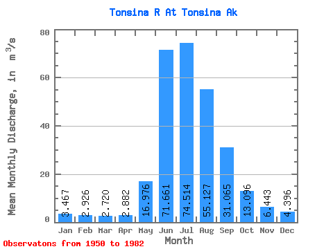
| Statistic | Jan | Feb | Mar | Apr | May | Jun | Jul | Aug | Sep | Oct | Nov | Dec | Annual |
|---|---|---|---|---|---|---|---|---|---|---|---|---|---|
| Mean | 3.47 | 2.93 | 2.72 | 2.88 | 16.98 | 71.66 | 74.51 | 55.13 | 31.07 | 13.10 | 6.44 | 4.40 | 23.88 |
| Standard Deviation | 1.02 | 0.89 | 0.79 | 0.84 | 8.62 | 25.43 | 15.84 | 10.79 | 14.40 | 5.29 | 2.49 | 1.49 | 4.47 |
| Min | 1.56 | 1.21 | 1.04 | 1.10 | 6.97 | 35.38 | 44.48 | 28.79 | 13.67 | 7.16 | 3.21 | 2.19 | 14.59 |
| Max | 6.11 | 6.17 | 5.39 | 4.88 | 40.30 | 132.66 | 115.79 | 83.53 | 80.31 | 29.94 | 13.60 | 8.49 | 32.93 |
| Coefficient of Variation | 0.29 | 0.30 | 0.29 | 0.29 | 0.51 | 0.35 | 0.21 | 0.20 | 0.46 | 0.40 | 0.39 | 0.34 | 0.19 |
 Return to R-Arctic Net Home Page