|
|
|||||||||||||||||
| Point ID: 9216 | Downloads | Plots | Site Data | Code: 15202000 |
|
|
|||||||||||||||||
| Download | |
|---|---|
| Site Descriptor Information | Site Time Series Data |
| Link to all available data | |
| View: | Time Series | All |
| Units: | m3/s |
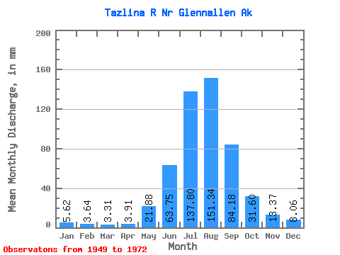
| Statistic | Jan | Feb | Mar | Apr | May | Jun | Jul | Aug | Sep | Oct | Nov | Dec | Annual |
|---|---|---|---|---|---|---|---|---|---|---|---|---|---|
| Mean | 5.62 | 3.67 | 3.31 | 3.91 | 21.88 | 63.75 | 137.78 | 151.31 | 84.17 | 31.59 | 13.37 | 8.06 | 517.80 |
| Standard Deviation | 2.04 | 0.80 | 0.67 | 2.15 | 11.79 | 19.36 | 24.88 | 28.27 | 33.75 | 11.46 | 4.88 | 2.59 | 85.36 |
| Min | 2.98 | 1.80 | 1.75 | 1.68 | 5.04 | 34.86 | 94.05 | 86.32 | 38.91 | 17.54 | 7.97 | 5.37 | 377.30 |
| Max | 10.46 | 5.12 | 4.49 | 10.25 | 46.96 | 113.88 | 198.91 | 226.75 | 172.74 | 75.71 | 27.95 | 15.35 | 724.82 |
| Coefficient of Variation | 0.36 | 0.22 | 0.20 | 0.55 | 0.54 | 0.30 | 0.18 | 0.19 | 0.40 | 0.36 | 0.36 | 0.32 | 0.17 |
 Return to R-Arctic Net Home Page