|
|
|||||||||||||||||
| Point ID: 9216 | Downloads | Plots | Site Data | Code: 15202000 |
|
|
|||||||||||||||||
| Download | |
|---|---|
| Site Descriptor Information | Site Time Series Data |
| Link to all available data | |

|
|
| View: | Statistics | Time Series |
| Units: | m3/s |
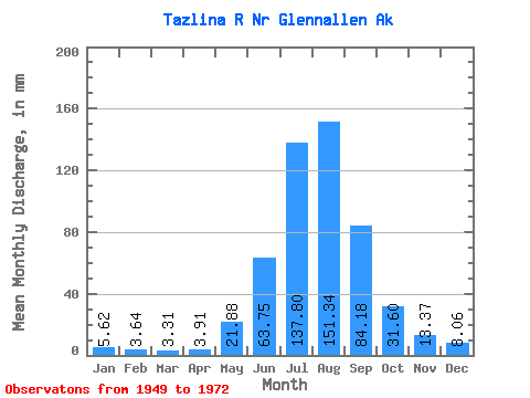
| Statistic | Jan | Feb | Mar | Apr | May | Jun | Jul | Aug | Sep | Oct | Nov | Dec | Annual |
|---|---|---|---|---|---|---|---|---|---|---|---|---|---|
| Mean | 5.62 | 3.67 | 3.31 | 3.91 | 21.88 | 63.75 | 137.78 | 151.31 | 84.17 | 31.59 | 13.37 | 8.06 | 517.80 |
| Standard Deviation | 2.04 | 0.80 | 0.67 | 2.15 | 11.79 | 19.36 | 24.88 | 28.27 | 33.75 | 11.46 | 4.88 | 2.59 | 85.36 |
| Min | 2.98 | 1.80 | 1.75 | 1.68 | 5.04 | 34.86 | 94.05 | 86.32 | 38.91 | 17.54 | 7.97 | 5.37 | 377.30 |
| Max | 10.46 | 5.12 | 4.49 | 10.25 | 46.96 | 113.88 | 198.91 | 226.75 | 172.74 | 75.71 | 27.95 | 15.35 | 724.82 |
| Coefficient of Variation | 0.36 | 0.22 | 0.20 | 0.55 | 0.54 | 0.30 | 0.18 | 0.19 | 0.40 | 0.36 | 0.36 | 0.32 | 0.17 |
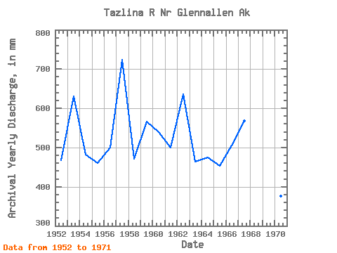
| Year | Jan | Feb | Mar | Apr | May | Jun | Jul | Aug | Sep | Oct | Nov | Dec | Annual | 1949 | 152.85 | 103.50 | 38.05 | 14.47 | 12.06 | 1950 | 10.46 | 4.70 | 2.68 | 2.81 | 16.64 | 61.13 | 138.31 | 168.84 | 161.28 | 1951 | 32.90 | 12.74 | 5.81 | 1952 | 3.84 | 3.00 | 3.18 | 2.87 | 14.34 | 48.26 | 123.07 | 150.33 | 50.56 | 38.09 | 18.63 | 15.35 | 467.27 | 1953 | 9.87 | 5.00 | 3.51 | 3.71 | 20.69 | 83.24 | 183.94 | 193.25 | 92.74 | 24.28 | 9.55 | 6.80 | 631.81 | 1954 | 5.37 | 3.90 | 3.40 | 2.67 | 19.83 | 62.66 | 119.39 | 149.90 | 75.16 | 26.68 | 10.72 | 5.70 | 481.98 | 1955 | 4.83 | 3.50 | 3.40 | 2.90 | 9.05 | 34.86 | 102.80 | 138.34 | 113.11 | 28.88 | 12.68 | 9.06 | 460.76 | 1956 | 4.42 | 3.01 | 2.47 | 4.03 | 31.75 | 51.79 | 130.79 | 148.25 | 77.99 | 29.09 | 12.21 | 7.57 | 499.41 | 1957 | 4.02 | 2.60 | 4.16 | 4.19 | 46.96 | 113.88 | 162.61 | 135.45 | 172.74 | 42.98 | 27.95 | 9.69 | 724.82 | 1958 | 7.10 | 3.46 | 3.07 | 2.91 | 19.84 | 72.11 | 142.44 | 140.65 | 50.22 | 17.54 | 9.20 | 6.30 | 471.04 | 1959 | 4.00 | 3.10 | 2.79 | 2.99 | 28.33 | 82.56 | 161.34 | 116.27 | 69.94 | 75.71 | 15.48 | 8.98 | 567.13 | 1960 | 6.84 | 4.40 | 4.27 | 3.95 | 36.03 | 67.58 | 130.93 | 141.51 | 87.34 | 35.07 | 13.23 | 12.56 | 540.01 | 1961 | 10.05 | 5.12 | 3.44 | 2.60 | 21.34 | 69.25 | 137.22 | 135.80 | 73.65 | 27.77 | 10.29 | 6.58 | 499.65 | 1962 | 4.83 | 3.90 | 4.06 | 5.20 | 34.11 | 85.78 | 148.00 | 226.75 | 88.32 | 25.27 | 9.68 | 5.37 | 636.31 | 1963 | 4.61 | 3.90 | 3.73 | 3.50 | 17.10 | 41.64 | 121.45 | 141.81 | 88.79 | 26.53 | 8.01 | 6.14 | 463.83 | 1964 | 5.15 | 4.00 | 3.18 | 2.87 | 6.26 | 73.68 | 132.76 | 139.31 | 74.28 | 22.94 | 7.97 | 5.85 | 475.24 | 1965 | 5.18 | 4.10 | 3.95 | 3.61 | 8.87 | 36.48 | 94.05 | 175.94 | 72.82 | 29.29 | 14.86 | 7.35 | 452.87 | 1966 | 5.37 | 3.80 | 3.07 | 3.36 | 18.57 | 66.52 | 142.71 | 149.42 | 55.79 | 34.96 | 19.11 | 7.13 | 505.75 | 1967 | 5.26 | 4.00 | 3.51 | 10.06 | 30.88 | 75.48 | 146.38 | 155.15 | 75.69 | 33.29 | 22.25 | 10.70 | 568.75 | 1968 | 5.37 | 3.99 | 4.49 | 10.25 | 32.36 | 70.66 | 198.91 | 192.72 | 56.81 | 28.04 | 11.66 | 7.50 | 616.83 | 1969 | 4.55 | 3.04 | 2.64 | 2.89 | 11.93 | 59.55 | 149.28 | 86.32 | 38.91 | 22.91 | 11.52 | 7.25 | 397.56 | 1970 | 4.36 | 2.76 | 2.58 | 2.75 | 9.98 | 41.30 | 100.07 | 123.06 | 48.66 | 27.36 | 11.53 | 6.04 | 377.30 | 1971 | 2.98 | 1.80 | 1.75 | 1.68 | 5.04 | 36.58 | 137.25 | 159.36 | 129.22 | 27.44 | 10.49 | 7.55 | 517.77 | 1972 | 5.17 | 3.75 | 3.56 | 4.30 | 41.37 | 67.43 | 127.51 | 158.92 | 78.50 |
|---|
 Return to R-Arctic Net Home Page