|
|
|||||||||||||||||
| Point ID: 9216 | Downloads | Plots | Site Data | Code: 15202000 |
|
|
|||||||||||||||||
| Download | |
|---|---|
| Site Descriptor Information | Site Time Series Data |
| Link to all available data | |
| View: | Time Series | All |
| Units: | mm |
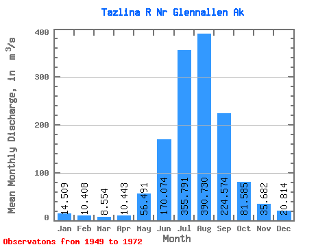
| Statistic | Jan | Feb | Mar | Apr | May | Jun | Jul | Aug | Sep | Oct | Nov | Dec | Annual |
|---|---|---|---|---|---|---|---|---|---|---|---|---|---|
| Mean | 14.51 | 10.41 | 8.55 | 10.44 | 56.49 | 170.07 | 355.79 | 390.73 | 224.57 | 81.58 | 35.68 | 20.81 | 113.46 |
| Standard Deviation | 5.27 | 2.25 | 1.72 | 5.75 | 30.44 | 51.65 | 64.25 | 73.01 | 90.05 | 29.60 | 13.02 | 6.69 | 18.70 |
| Min | 7.68 | 5.11 | 4.53 | 4.48 | 13.03 | 93.00 | 242.86 | 222.90 | 103.82 | 45.28 | 21.26 | 13.88 | 82.67 |
| Max | 27.01 | 14.50 | 11.58 | 27.34 | 121.26 | 303.82 | 513.63 | 585.52 | 460.86 | 195.50 | 74.57 | 39.64 | 158.82 |
| Coefficient of Variation | 0.36 | 0.22 | 0.20 | 0.55 | 0.54 | 0.30 | 0.18 | 0.19 | 0.40 | 0.36 | 0.36 | 0.32 | 0.17 |
 Return to R-Arctic Net Home Page