|
|
|||||||||||||||||
| Point ID: 9216 | Downloads | Plots | Site Data | Code: 15202000 |
|
|
|||||||||||||||||
| Download | |
|---|---|
| Site Descriptor Information | Site Time Series Data |
| Link to all available data | |
|
|
| View: | Statistics | Time Series |
| Units: | mm |
| Statistic | Jan | Feb | Mar | Apr | May | Jun | Jul | Aug | Sep | Oct | Nov | Dec | Annual |
|---|---|---|---|---|---|---|---|---|---|---|---|---|---|
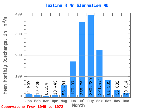
| Mean | 14.51 | 10.41 | 8.55 | 10.44 | 56.49 | 170.07 | 355.79 | 390.73 | 224.57 | 81.58 | 35.68 | 20.81 | 113.46 |
| Standard Deviation | 5.27 | 2.25 | 1.72 | 5.75 | 30.44 | 51.65 | 64.25 | 73.01 | 90.05 | 29.60 | 13.02 | 6.69 | 18.70 |
| Min | 7.68 | 5.11 | 4.53 | 4.48 | 13.03 | 93.00 | 242.86 | 222.90 | 103.82 | 45.28 | 21.26 | 13.88 | 82.67 |
| Max | 27.01 | 14.50 | 11.58 | 27.34 | 121.26 | 303.82 | 513.63 | 585.52 | 460.86 | 195.50 | 74.57 | 39.64 | 158.82 |
| Coefficient of Variation | 0.36 | 0.22 | 0.20 | 0.55 | 0.54 | 0.30 | 0.18 | 0.19 | 0.40 | 0.36 | 0.36 | 0.32 | 0.17 |
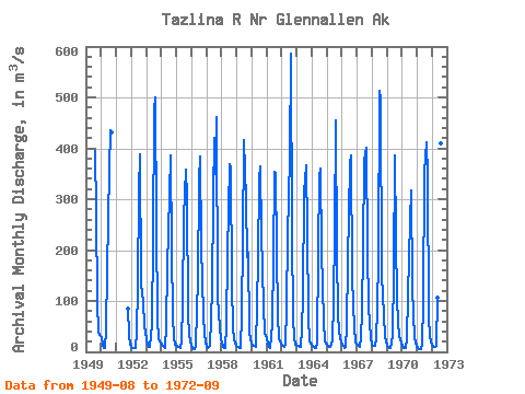
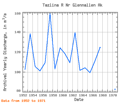
| Year | Jan | Feb | Mar | Apr | May | Jun | Jul | Aug | Sep | Oct | Nov | Dec | Annual | 1949 | 394.70 | 276.13 | 98.26 | 38.60 | 31.15 | 1950 | 27.01 | 13.31 | 6.92 | 7.50 | 42.96 | 163.10 | 357.16 | 435.99 | 430.29 | 1951 | 84.95 | 33.98 | 15.01 | 1952 | 9.91 | 8.49 | 8.21 | 7.65 | 37.02 | 128.77 | 317.81 | 388.19 | 134.88 | 98.36 | 49.71 | 39.64 | 102.39 | 1953 | 25.48 | 14.16 | 9.06 | 9.91 | 53.44 | 222.08 | 474.99 | 499.02 | 247.41 | 62.69 | 25.48 | 17.56 | 138.44 | 1954 | 13.88 | 11.04 | 8.78 | 7.12 | 51.21 | 167.17 | 308.30 | 387.08 | 200.53 | 68.90 | 28.59 | 14.71 | 105.61 | 1955 | 12.46 | 9.91 | 8.78 | 7.73 | 23.38 | 93.00 | 265.46 | 357.24 | 301.78 | 74.56 | 33.84 | 23.38 | 100.96 | 1956 | 11.42 | 8.53 | 6.38 | 10.76 | 81.98 | 138.18 | 337.75 | 382.83 | 208.07 | 75.13 | 32.58 | 19.54 | 109.43 | 1957 | 10.39 | 7.36 | 10.75 | 11.19 | 121.26 | 303.82 | 419.91 | 349.76 | 460.86 | 110.97 | 74.57 | 25.01 | 158.82 | 1958 | 18.32 | 9.82 | 7.93 | 7.75 | 51.23 | 192.38 | 367.83 | 363.20 | 133.98 | 45.28 | 24.54 | 16.28 | 103.21 | 1959 | 10.34 | 8.78 | 7.21 | 7.99 | 73.17 | 220.27 | 416.62 | 300.24 | 186.60 | 195.50 | 41.31 | 23.18 | 124.27 | 1960 | 17.68 | 12.48 | 11.03 | 10.55 | 93.03 | 180.31 | 338.08 | 365.42 | 233.03 | 90.56 | 35.31 | 32.43 | 118.33 | 1961 | 25.94 | 14.50 | 8.87 | 6.94 | 55.11 | 184.77 | 354.33 | 350.67 | 196.50 | 71.70 | 27.46 | 16.99 | 109.48 | 1962 | 12.46 | 11.04 | 10.48 | 13.88 | 88.09 | 228.85 | 382.19 | 585.52 | 235.63 | 65.27 | 25.83 | 13.88 | 139.43 | 1963 | 11.89 | 11.04 | 9.63 | 9.35 | 44.16 | 111.10 | 313.61 | 366.20 | 236.88 | 68.50 | 21.38 | 15.86 | 101.63 | 1964 | 13.31 | 11.33 | 8.21 | 7.65 | 16.17 | 196.59 | 342.83 | 359.73 | 198.18 | 59.25 | 21.26 | 15.10 | 104.13 | 1965 | 13.38 | 11.61 | 10.19 | 9.63 | 22.91 | 97.33 | 242.86 | 454.32 | 194.29 | 75.64 | 39.64 | 18.97 | 99.23 | 1966 | 13.88 | 10.76 | 7.93 | 8.97 | 47.97 | 177.48 | 368.50 | 385.84 | 148.84 | 90.27 | 50.97 | 18.41 | 110.82 | 1967 | 13.59 | 11.33 | 9.06 | 26.85 | 79.73 | 201.38 | 377.98 | 400.64 | 201.94 | 85.97 | 59.35 | 27.63 | 124.62 | 1968 | 13.86 | 11.31 | 11.58 | 27.34 | 83.57 | 188.50 | 513.63 | 497.65 | 151.56 | 72.41 | 31.10 | 19.36 | 135.16 | 1969 | 11.74 | 8.61 | 6.81 | 7.72 | 30.80 | 158.87 | 385.47 | 222.90 | 103.82 | 59.16 | 30.72 | 18.73 | 87.11 | 1970 | 11.25 | 7.83 | 6.65 | 7.33 | 25.77 | 110.19 | 258.40 | 317.78 | 129.82 | 70.66 | 30.77 | 15.60 | 82.67 | 1971 | 7.68 | 5.11 | 4.53 | 4.48 | 13.03 | 97.58 | 354.41 | 411.51 | 344.74 | 70.86 | 27.99 | 19.50 | 113.45 | 1972 | 13.34 | 10.64 | 9.18 | 11.47 | 106.83 | 179.91 | 329.27 | 410.38 | 209.43 |
|---|
 Return to R-Arctic Net Home Page