|
|
|||||||||||||||||
| Point ID: 8909 | Downloads | Plots | Site Data | Code: 70572 |
|
|
|||||||||||||||||
| Download | |
|---|---|
| Site Descriptor Information | Site Time Series Data |
| Link to all available data | |
|
|
| View: | Statistics | Time Series |
| Units: | mm |
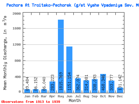
| Statistic | Jan | Feb | Mar | Apr | May | Jun | Jul | Aug | Sep | Oct | Nov | Dec | Annual |
|---|---|---|---|---|---|---|---|---|---|---|---|---|---|
| Mean | 89.48 | 86.15 | 86.04 | 283.22 | 1815.77 | 1151.15 | 362.07 | 314.08 | 338.09 | 468.35 | 303.78 | 131.14 | 451.62 |
| Standard Deviation | 13.66 | 13.74 | 15.45 | 297.59 | 421.37 | 512.78 | 173.56 | 213.13 | 177.34 | 185.24 | 137.45 | 35.13 | 91.09 |
| Min | 70.00 | 64.40 | 51.20 | 70.00 | 800.00 | 326.00 | 109.00 | 84.50 | 79.10 | 109.00 | 97.20 | 82.00 | 229.35 |
| Max | 120.00 | 120.00 | 120.00 | 1190.00 | 2470.00 | 2720.00 | 728.00 | 930.00 | 726.00 | 822.00 | 530.00 | 229.00 | 609.27 |
| Coefficient of Variation | 0.15 | 0.16 | 0.18 | 1.05 | 0.23 | 0.45 | 0.48 | 0.68 | 0.53 | 0.40 | 0.45 | 0.27 | 0.20 |
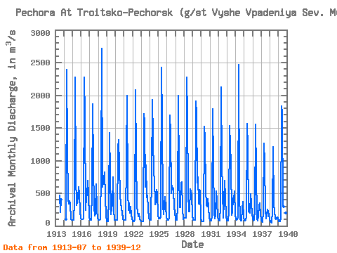
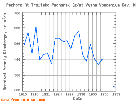
| Year | Jan | Feb | Mar | Apr | May | Jun | Jul | Aug | Sep | Oct | Nov | Dec | Annual | 1913 | 467.00 | 211.00 | 403.00 | 1914 | 98.00 | 2390.00 | 1200.00 | 408.00 | 342.00 | 385.00 | 337.00 | 102.00 | 87.00 | 1915 | 87.30 | 87.30 | 87.30 | 376.00 | 2270.00 | 764.00 | 318.00 | 438.00 | 601.00 | 485.00 | 223.00 | 110.00 | 487.24 | 1916 | 107.00 | 107.00 | 107.00 | 115.00 | 2270.00 | 1670.00 | 244.00 | 470.00 | 466.00 | 698.00 | 475.00 | 136.00 | 572.08 | 1917 | 88.00 | 88.00 | 88.00 | 523.00 | 1870.00 | 928.00 | 289.00 | 152.00 | 186.00 | 636.00 | 256.00 | 118.00 | 435.17 | 1918 | 96.40 | 96.40 | 96.40 | 98.00 | 800.00 | 2720.00 | 592.00 | 661.00 | 726.00 | 822.00 | 449.00 | 154.00 | 609.27 | 1919 | 70.00 | 70.00 | 70.00 | 418.00 | 1430.00 | 817.00 | 182.00 | 278.00 | 330.00 | 751.00 | 248.00 | 91.00 | 396.25 | 1920 | 91.00 | 91.00 | 91.00 | 1190.00 | 1320.00 | 936.00 | 450.00 | 359.00 | 248.00 | 218.00 | 97.20 | 90.00 | 431.77 | 1921 | 94.00 | 94.00 | 94.00 | 1070.00 | 1990.00 | 525.00 | 247.00 | 352.00 | 203.00 | 297.00 | 170.00 | 108.00 | 437.00 | 1922 | 73.00 | 73.00 | 73.00 | 98.80 | 2080.00 | 1050.00 | 296.00 | 224.00 | 142.00 | 183.00 | 109.00 | 82.00 | 373.65 | 1923 | 70.00 | 70.00 | 70.00 | 70.00 | 1720.00 | 1590.00 | 596.00 | 930.00 | 435.00 | 468.00 | 257.00 | 127.00 | 533.58 | 1924 | 87.00 | 87.00 | 87.00 | 777.00 | 1930.00 | 786.00 | 728.00 | 333.00 | 382.00 | 555.00 | 498.00 | 158.00 | 534.00 | 1925 | 110.00 | 110.00 | 110.00 | 142.00 | 2430.00 | 1590.00 | 308.00 | 178.00 | 313.00 | 445.00 | 287.00 | 133.00 | 513.00 | 1926 | 87.00 | 87.00 | 87.00 | 114.00 | 1690.00 | 1420.00 | 499.00 | 622.00 | 554.00 | 574.00 | 249.00 | 229.00 | 517.67 | 1927 | 96.00 | 96.00 | 96.00 | 289.00 | 2000.00 | 776.00 | 285.00 | 289.00 | 660.00 | 672.00 | 261.00 | 104.00 | 468.67 | 1928 | 120.00 | 120.00 | 120.00 | 120.00 | 2270.00 | 1700.00 | 508.00 | 220.00 | 220.00 | 566.00 | 481.00 | 167.00 | 551.00 | 1929 | 92.00 | 92.00 | 92.00 | 92.00 | 1910.00 | 1710.00 | 657.00 | 743.00 | 341.00 | 550.00 | 530.00 | 111.00 | 576.67 | 1930 | 70.00 | 70.00 | 70.00 | 70.00 | 1520.00 | 1330.00 | 554.00 | 328.00 | 298.00 | 412.00 | 283.00 | 127.00 | 427.67 | 1931 | 82.00 | 82.00 | 82.00 | 149.00 | 1790.00 | 965.00 | 196.00 | 111.00 | 163.00 | 535.00 | 385.00 | 138.00 | 389.83 | 1932 | 96.60 | 88.30 | 80.80 | 293.00 | 2120.00 | 948.00 | 543.00 | 126.00 | 364.00 | 691.00 | 442.00 | 161.00 | 496.14 | 1933 | 82.00 | 82.00 | 82.00 | 207.00 | 1530.00 | 952.00 | 163.00 | 219.00 | 422.00 | 416.00 | 530.00 | 173.00 | 404.83 | 1934 | 105.00 | 93.50 | 104.00 | 123.00 | 2470.00 | 490.00 | 109.00 | 84.70 | 79.10 | 255.00 | 370.00 | 125.00 | 367.36 | 1935 | 83.40 | 79.00 | 88.60 | 132.00 | 1560.00 | 1200.00 | 221.00 | 207.00 | 202.00 | 494.00 | 342.00 | 188.00 | 399.75 | 1936 | 104.00 | 84.00 | 87.50 | 240.00 | 1550.00 | 833.00 | 118.00 | 84.50 | 145.00 | 318.00 | 352.00 | 165.00 | 340.08 | 1937 | 99.00 | 73.60 | 64.00 | 213.00 | 1260.00 | 974.00 | 252.00 | 114.00 | 171.00 | 256.00 | 164.00 | 98.70 | 311.61 | 1938 | 73.20 | 64.40 | 51.20 | 234.00 | 1210.00 | 326.00 | 221.00 | 112.00 | 99.40 | 109.00 | 139.00 | 113.00 | 229.35 | 1939 | 73.20 | 68.30 | 72.20 | 112.00 | 1830.00 | 1730.00 | 325.00 | 292.00 | 590.00 | 434.00 | 199.00 | 116.00 | 486.81 |
|---|
 Return to R-Arctic Net Home Page