|
|
|||||||||||||||||
| Point ID: 8876 | Downloads | Plots | Site Data | Code: 70472 |
|
|
|||||||||||||||||
| Download | |
|---|---|
| Site Descriptor Information | Site Time Series Data |
| Link to all available data | |
| View: | Time Series | All |
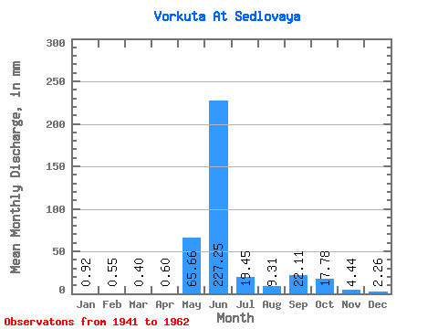
| Units: | m3/s |
| Statistic | Jan | Feb | Mar | Apr | May | Jun | Jul | Aug | Sep | Oct | Nov | Dec | Annual |
|---|---|---|---|---|---|---|---|---|---|---|---|---|---|
| Mean | 0.92 | 0.56 | 0.40 | 0.60 | 65.65 | 227.25 | 19.45 | 9.30 | 22.11 | 17.77 | 4.44 | 2.26 | 489.11 |
| Standard Deviation | 0.52 | 0.36 | 0.40 | 0.66 | 91.14 | 150.84 | 9.63 | 7.40 | 16.04 | 15.01 | 2.00 | 1.30 | 79.12 |
| Min | 0.29 | 0.15 | 0.06 | 0.04 | 1.63 | 26.70 | 7.36 | 2.87 | 5.34 | 5.93 | 1.45 | 0.91 | 390.70 |
| Max | 1.61 | 1.05 | 0.95 | 1.76 | 229.87 | 463.89 | 38.39 | 25.29 | 49.84 | 48.16 | 7.68 | 4.44 | 596.77 |
| Coefficient of Variation | 0.57 | 0.66 | 0.99 | 1.09 | 1.39 | 0.66 | 0.49 | 0.80 | 0.72 | 0.84 | 0.45 | 0.57 | 0.16 |
 Return to R-Arctic Net Home Page