|
|
|||||||||||||||||
| Point ID: 8876 | Downloads | Plots | Site Data | Code: 70472 |
|
|
|||||||||||||||||
| Download | |
|---|---|
| Site Descriptor Information | Site Time Series Data |
| Link to all available data | |
| View: | Time Series | All |
| Units: | mm |
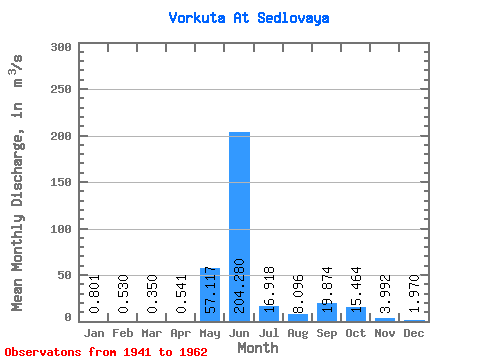
| Statistic | Jan | Feb | Mar | Apr | May | Jun | Jul | Aug | Sep | Oct | Nov | Dec | Annual |
|---|---|---|---|---|---|---|---|---|---|---|---|---|---|
| Mean | 0.80 | 0.53 | 0.35 | 0.54 | 57.12 | 204.28 | 16.92 | 8.10 | 19.87 | 15.46 | 3.99 | 1.97 | 36.11 |
| Standard Deviation | 0.46 | 0.35 | 0.35 | 0.59 | 79.30 | 135.60 | 8.38 | 6.44 | 14.42 | 13.06 | 1.80 | 1.13 | 5.84 |
| Min | 0.25 | 0.14 | 0.05 | 0.04 | 1.42 | 24.00 | 6.40 | 2.50 | 4.80 | 5.16 | 1.30 | 0.79 | 28.84 |
| Max | 1.40 | 1.00 | 0.83 | 1.58 | 200.00 | 417.00 | 33.40 | 22.00 | 44.80 | 41.90 | 6.90 | 3.86 | 44.06 |
| Coefficient of Variation | 0.57 | 0.66 | 0.99 | 1.09 | 1.39 | 0.66 | 0.49 | 0.80 | 0.72 | 0.84 | 0.45 | 0.57 | 0.16 |
 Return to R-Arctic Net Home Page