|
|
|||||||||||||||||
| Point ID: 8876 | Downloads | Plots | Site Data | Code: 70472 |
|
|
|||||||||||||||||
| Download | |
|---|---|
| Site Descriptor Information | Site Time Series Data |
| Link to all available data | |
|
|
| View: | Statistics | Time Series |
| Units: | m3/s |
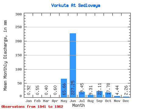
| Statistic | Jan | Feb | Mar | Apr | May | Jun | Jul | Aug | Sep | Oct | Nov | Dec | Annual |
|---|---|---|---|---|---|---|---|---|---|---|---|---|---|
| Mean | 0.92 | 0.56 | 0.40 | 0.60 | 65.65 | 227.25 | 19.45 | 9.30 | 22.11 | 17.77 | 4.44 | 2.26 | 489.11 |
| Standard Deviation | 0.52 | 0.36 | 0.40 | 0.66 | 91.14 | 150.84 | 9.63 | 7.40 | 16.04 | 15.01 | 2.00 | 1.30 | 79.12 |
| Min | 0.29 | 0.15 | 0.06 | 0.04 | 1.63 | 26.70 | 7.36 | 2.87 | 5.34 | 5.93 | 1.45 | 0.91 | 390.70 |
| Max | 1.61 | 1.05 | 0.95 | 1.76 | 229.87 | 463.89 | 38.39 | 25.29 | 49.84 | 48.16 | 7.68 | 4.44 | 596.77 |
| Coefficient of Variation | 0.57 | 0.66 | 0.99 | 1.09 | 1.39 | 0.66 | 0.49 | 0.80 | 0.72 | 0.84 | 0.45 | 0.57 | 0.16 |
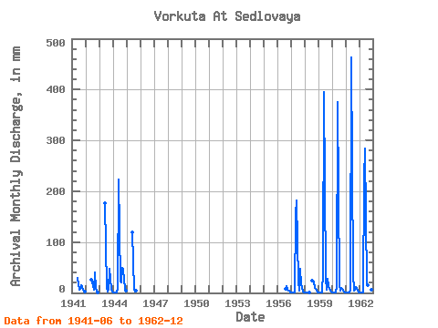
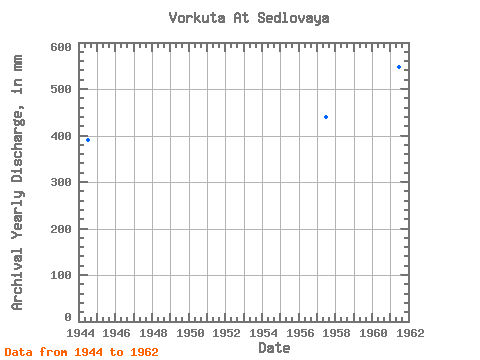
| Year | Jan | Feb | Mar | Apr | May | Jun | Jul | Aug | Sep | Oct | Nov | Dec | Annual | 1941 | 29.81 | 7.36 | 8.04 | 15.35 | 12.07 | 2.89 | 2.07 | 1942 | 26.70 | 15.06 | 6.90 | 40.60 | 7.59 | 1.45 | 1943 | 175.77 | 10.00 | 2.87 | 6.90 | 48.16 | 7.68 | 3.56 | 1944 | 1.61 | 1.05 | 0.95 | 0.45 | 9.20 | 222.49 | 24.02 | 20.92 | 49.84 | 46.43 | 7.34 | 4.14 | 390.70 | 1945 | 119.03 | 7.36 | 3.56 | 5.34 | 1956 | 7.54 | 14.13 | 5.93 | 3.67 | 1.39 | 1957 | 0.61 | 0.37 | 0.06 | 0.57 | 158.61 | 181.33 | 22.76 | 5.15 | 47.84 | 17.36 | 3.52 | 1.26 | 439.18 | 1958 | 0.37 | 0.17 | 0.07 | 0.04 | 1.63 | 24.14 | 25.29 | 23.14 | 9.48 | 5.48 | 0.91 | 1959 | 0.29 | 0.15 | 0.06 | 0.07 | 41.72 | 394.92 | 29.77 | 5.62 | 26.92 | 13.22 | 4.84 | 2.10 | 524.28 | 1960 | 1.21 | 0.45 | 0.16 | 0.11 | 11.21 | 374.89 | 17.24 | 4.80 | 9.45 | 7.80 | 2.00 | 1.62 | 435.85 | 1961 | 1.46 | 0.93 | 0.68 | 1.22 | 7.30 | 463.89 | 38.39 | 4.41 | 6.56 | 11.49 | 4.52 | 1.15 | 547.90 | 1962 | 0.91 | 0.78 | 0.83 | 1.76 | 229.87 | 283.67 | 17.82 | 16.55 | 19.25 | 15.98 | 5.46 | 4.44 | 596.77 |
|---|
 Return to R-Arctic Net Home Page