|
|
|||||||||||||||||
| Point ID: 8874 | Downloads | Plots | Site Data | Code: 70460 |
|
|
|||||||||||||||||
| Download | |
|---|---|
| Site Descriptor Information | Site Time Series Data |
| Link to all available data | |
| View: | Time Series | All |
| Units: | m3/s |
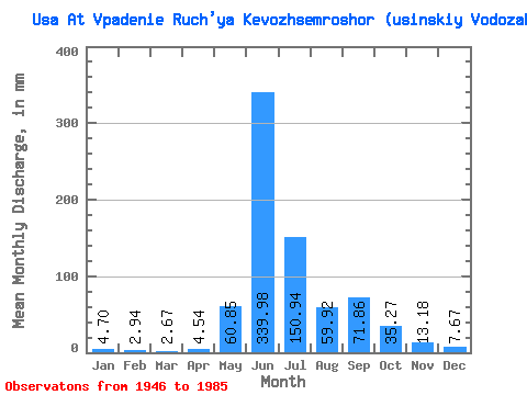
| Statistic | Jan | Feb | Mar | Apr | May | Jun | Jul | Aug | Sep | Oct | Nov | Dec | Annual |
|---|---|---|---|---|---|---|---|---|---|---|---|---|---|
| Mean | 4.70 | 2.97 | 2.67 | 4.54 | 60.84 | 339.98 | 150.92 | 59.91 | 71.86 | 35.26 | 13.18 | 7.67 | 757.68 |
| Standard Deviation | 1.61 | 1.21 | 1.16 | 5.01 | 76.97 | 94.70 | 80.35 | 28.08 | 33.01 | 20.37 | 5.81 | 2.81 | 113.82 |
| Min | 1.73 | 0.78 | 0.64 | 0.89 | 2.84 | 158.89 | 64.61 | 24.59 | 25.11 | 6.74 | 4.50 | 1.57 | 521.39 |
| Max | 8.10 | 6.30 | 4.93 | 26.95 | 307.14 | 528.65 | 354.04 | 127.09 | 153.03 | 79.43 | 25.19 | 14.90 | 1004.45 |
| Coefficient of Variation | 0.34 | 0.41 | 0.44 | 1.10 | 1.27 | 0.28 | 0.53 | 0.47 | 0.46 | 0.58 | 0.44 | 0.37 | 0.15 |
 Return to R-Arctic Net Home Page